THE MODERN MEDIUM-SCALE MAPPING OF THE AVALANCE DANGER IN THE UKRAINIAN CARPATHIANS
Oleksandr Aksiuk, Valentyn Lanshyn, Hanna Honcharenko
Ukrainian Hydrometeorological Institute, Kyiv, Ukraine
Corresponding author: O. Aksiuk, Ukrainian Hydrometeorological Institute, 37, Nauki Prospect, 03028, Kyiv, Ukraine, aksiukalex@gmail.com
ABSTRACT
There is a characteristic phenomenon of mountain landscape in Avalanche. Mountain development entails the need to take into account the avalanche hazard. The important task of the Hydrometeorological Service of Ukraine is to increase the effectiveness of forecasting avalanche danger in mountainous areas of Ukraine. One of the elements on the way to its solution is the digital display of mountain areas in the form of thematic maps. The intensive development of modern GIS technologies and the availability of digital terrain models make it possible to create various thematic maps. The avalanche activity is affected by meteorological and geomorphological factors. Using DEM based on SRTM 1, an avalanche hazard map of Ukrainian Carpathians was compiled. The map is based on the average maximum snow height and the steepness of the slopes. The proposed map will improve the quality of avalanche forecasts and will allow you to determine the need for avalanche exploration if the intended area of construction falls into the avalanche zone and protect users from unnecessary danger. An algorithm for constructing thematic (avalanche) digital maps using satellite data SRTM 1 has been elaborated.
Keywords: avalanche, avalanche hazard, map slope steepness, snow depth
INTRODUCTION
The modern intensive development of information technologies aimed at streamlining and qualitative processing of huge data sets has given impetus for creation of multifunctional geoinformation systems (GIS). Instead of traditional paper, time-consuming, routine assembly and processing, digital maps and electronic databases have come. These innovations have enabled scientists to significantly deepen their knowledge of avalanche science.
The avalanche is a natural component of the environment. They are very widespread and regular. Avalanches occur on mountain slopes and occupy a special place among the geophysical processes occurring in the hydrosphere. Like other natural phenomena, such as hail, people usually perceive avalanches as a danger - a natural disaster. Because of that, the term "avalanche danger" is widely used in the literature.
Due to the regularity of avalanches the following formulation of this concept was proposed:
avalanche danger is a naturally occurring influence of avalanches on the natural environment and a fundamental possibility of their impact on the population and engineering structures (Bozhinsky A.N, Losev K.S, 1987).
There are different ways to classify the extent of an avalanche or avalanche hazard. The avalanches have great destructive power, especially when they reach large sizes. However, large and giant avalanches do not occur frequently. Usually there are also the most common landslides, small avalanches and avalanches of medium size in the mountains.
The climate of the region determines its avalanche regime. Avalanches can occur wherever there is snow cover and steep slopes, but they reach a truly devastating force in high mountain areas, where they are favored by climatic and orographic conditions.
Avalanche and avalanche hazards are of considerable interest for the development of mountain areas and the exploitation of economic facilities, engineering structures, communications and natural resources at risk of avalanche.
The occurrence of avalanches depends on a complex set of factors: climatic, hydrometeorological, geomorphological, geobotanical, physic-mechanical, etc.
Avalanches belong to especially dangerous hydrometeorological natural phenomena, because of the threat to human life. Under the natural conditions, the main physical cause of avalanches is the loss of snow resistance on a mountain slope. Violation of stability can occur due to displacement or subsidence, static deformation under the force of snow, precipitation, redistribution of snow by wind and other changes in the tangent and normal stresses in the snow. Even the local loss of stability can cause a dynamic process of avalanche formation under boundary equilibrium conditions.
The maps that are presented here are built using geoinformation systems (GIS) using geoinformation technologies and are geographic (Samoilenko V.M., 2010). In content, these maps belong to thematic maps of natural phenomena.
METHODS AND DATA
The digital elevation model (DEM) data were used for their development (Fig. 1). The digital terrain model is a file of elevation values. These marks are confined to the nodes of the small regular grid. The grid nodes are organized in the form of a rectangular matrix. It is a digital expression of the elevation characteristics of the relief on a topographic map (Fig. 2, 3). The DEM has a distance of 30 m in pixel and a vertical accuracy of about 15 m.
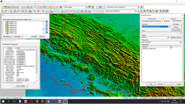
Fig. 1. Workspace of 12 files (N47E02-05, N48E02-05, N49E02-05) of digital elevation model (DEM) with SRTM 1sec space altitude data
SRTM 1 sec space altitude data were used to construct the topographic base. The Shuttle Radar Topographic Mission (SRTM) datasets are a joint effort of the both National Aeronautics and Space Administration (NASA) and the National Geospatial Intelligence Agency (NGA - formerly known as the National Assembly and Mapping Agency), and with the participation of the German and Italian Space Agencies, to generate an almost global digital terrain model (DEM) of the Earth, from about 60 ° north to 56 ° south, using radar interferometry. The SRTM tool consisted of an Imaging radar-C (SIR-C) spacecraft modified on an additional mast of a 60-meter antenna removed from the space station to form a baseline interferometer (Tom G. Farr, Mike Kabrick, 2000).
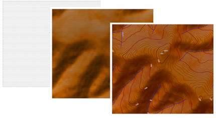
Fig. 2. Stages of construction of topographic basis of the map
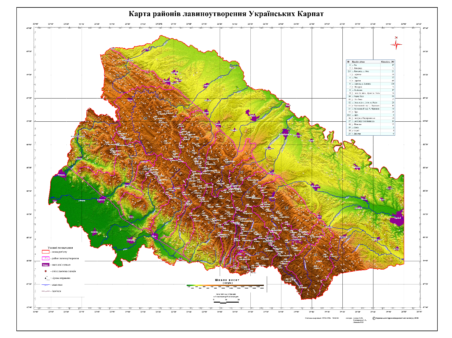
Fig. 3. Map of avalanche formation areas of Ukrainian Carpathians based on the DEM
The maps presented in this work are built using GIS. In content, these maps belong to the thematic maps of natural phenomena (Aksiuk O.M., Lanshin V.P. and Honcharenko H.A., 2018).
The creation of an avalanche hazard map was preceded by the processing of long-term observations of snow cover on the state hydrometeorological network. Information was processed from 247 observation points (Grishchenko V.F., Aksiuk O.M. and Honcharenko H.A., 2013). A graphic-analytical analysis of the change in the thickness of the snow cover with the height of the area was carried out. The dependences of this variability on the southern and northern macro slopes are obtained (Fig.4).
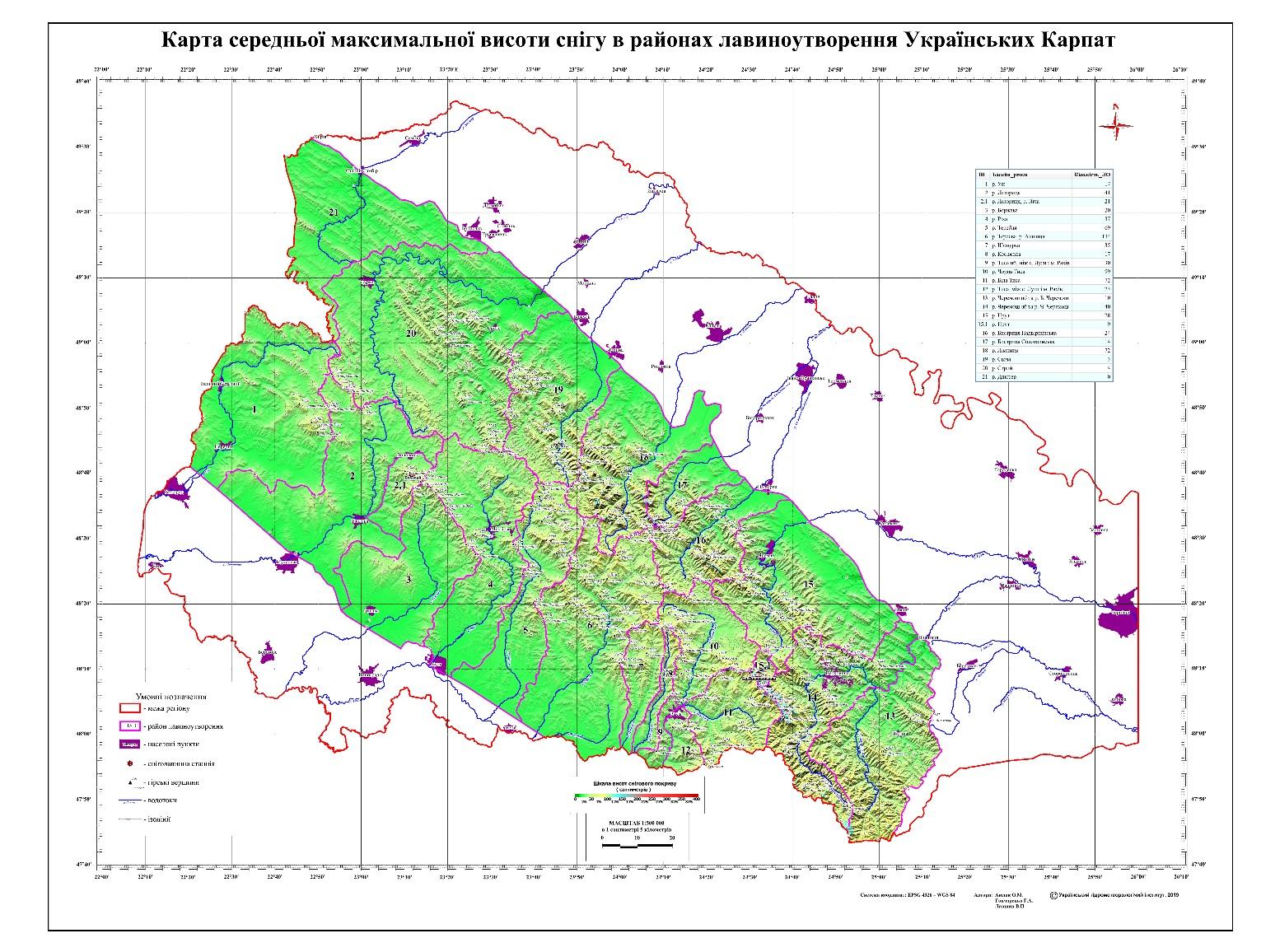
Fig. 4. Map of the average maximum depth of snow in the avalanche regions
(Ukrainian Carpathians)
In the Ukrainian Carpathians there are about 1000 avalanche centers. More than 600 of them are located in the belt of mountain-glacial relief, that is, above the forest border. The slope of the surface of avalanches is small (20-400) in comparison with the Alps and the Caucasus. Cases of avalanches from surfaces of 180 are noted (Grishchenko V.F., Aksiuk O.M. and Honcharenko H.A., 2014).
Based on the calculations made, a map of the average maximum snow height is constructed. Taking into account the DEM, a map of the steepness of the slopes was built. The 8 ranges were selected taking into account the degree of manifestation of avalanche activity: 0-120, 12-250, 25-300, 30-350, 35-400, 40-450, 45-500,50-600 (Fig. 5-7).
To build an avalanche hazard map, a relief was identified within the areas of avalanche formation. The following gradations of the average maximum depth of snow cover were also identified - less than 30 cm, 30-50, 50-70, more than 70 cm. For the entire selected territory, the 4 levels of avalanche hazard were determined. It is generally accepted that for the formation of avalanches the lower limit of snow depth is 30 cm and the slope with a criticality of more than 12 degrees. The depth of snow is directly related to the height of the terrain and topography. Having identified 4 gradations (zones) of the depth of snow and setting a lower limit for the occurrence of avalanches, based on the obtained dependences, we constructed an avalanche hazard map. The selected zones respond: with a significant, moderate, weak and potential danger and with a zone with its absence (Fig.8).
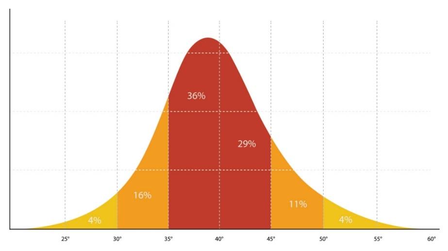
Fig. 5. Most avalanches occur on slopes 350 to 450
(http://mountainacademy.salomon.com/en/demo/50/conditions-for-a-slab-avalanche)
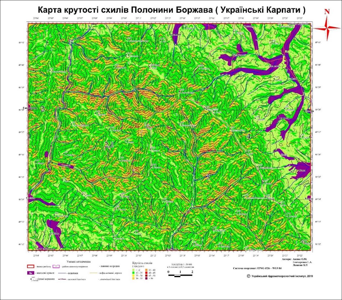
Fig. 6. Map of steepness of slopes (Polonyna Borzhava, Ukrainian Carpathians)
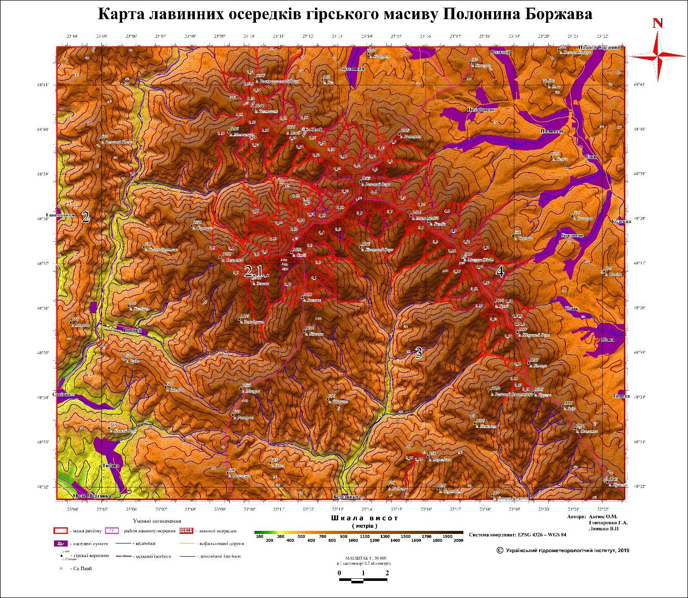
Fig. 7. Map of avalanche sites (Polonyna Borzhava, Ukrainian Carpathians)
Mountainous territory is divided into four avalanche danger zones with corresponding background values of the average maximum height of snow cover. The area with no avalanche danger is located on relatively flat terrain with an average maximum snow height of less than 30 cm. The average maximum height of snow cover in the zone of weak and potential avalanche danger is within 30-50 cm. The zone of moderate avalanche danger corresponds to the range of values of this characteristic 50-70 cm. The zone of significant avalanche danger covers the area where the average maximum height of snow cover exceeds 70 cm.
CONCLUSIONS
The metadata conversion algorithm is developed and the technology of compilation of thematic maps using SRTM high-altitude data, aerospace images, raster and vector maps is worked out. The map is intended for scientific, geographic, recreational study of the territory.
The maps and developments offered in this work are capable of improving the quality of avalanche forecasts and enabling users to determine the need for avalanche exploration if the intended area of construction falls into an avalanche zone and protects users from unnecessary danger. It should be remembered that an avalanche threat may increase if the "avalanche forests" are destroyed by pollution or unintentionally cut down.
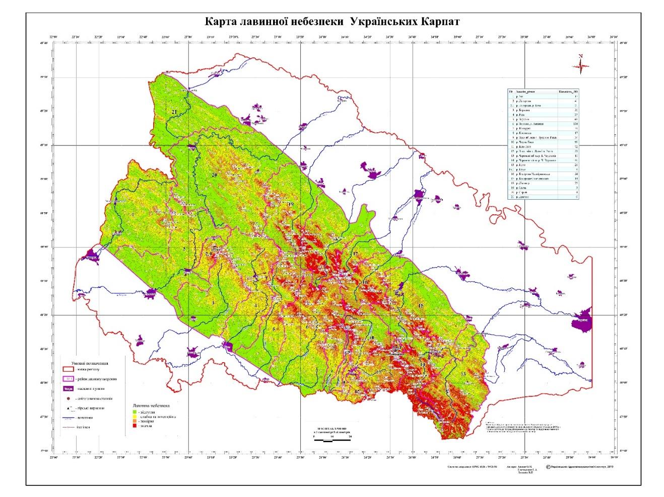
Fig. 8. Avalanche hazard map of Ukrainian Carpathians
REFERENCES
- Аксюк О.М., Ланшин В.П., Гончаренко Г.А Тематичне цифрове картування районів діяльності сніголавинних станцій України // VII Всеукраїнська наукова конференція «Проблеми гідрології, гідрохімії, гідроекології», присвячена 100-річчю від дня заснування Національної академії наук України (13-14 листопада 2018 р., м. Київ). ТЕЗИ ДОПОВІДЕЙ. – К., Ніка-Центр, 2018. – С.49-50. [ Aksiuk O.M, V.P. Lanshin V.P., Honcharenko H.A. Thematic digital mapping of avalanche stations areas in Ukraine // VII All-Ukrainian Scientific Conference "Problems of Hydrology, Hydrochemistry, Hydroecology", dedicated to the 100-th anniversary of the founding of the National Academy of Sciences of Ukraine (November 13-14, 2018, Kyiv).Book of abstract, К., NikaCentr, 2018. – P.49-50].
- Божинский А.Н., Лосев К.С. Основы лавиноведения. Л.: Гидрометеоиздат, 1987. — 280 с. [Bozhinsky A.N, Losev K.S, Fundamentals of avalanche science L.: Hydrometeoizdat, 1987. — 280 P].
- Грищенко В.Ф., Аксюк О.М., Гончаренко Г.А. Довідник зі снігового покриву в горах України (Карпати, Крим). – Український науково-дослідний гідрометеорологічний інститут. - К.: 2013, 218 с. [Grishchenko V.F., Aksiuk O.M. and Honcharenko H.A., 2013. Dovidnyk zi snihovoho pokryvu v horah Ukrainy (Karpaty, Krym). – Ukrainskiy naukovo-doslidnyi hidrometeorolohichnyi instytut – K.: 2013, 218 pages.) The pdf of the handbook is online available here: http://uhmi.org.ua/pub/].
- Грищенко В.Ф., Аксюк О.М., Гончаренко Г.А. Кадастр снігових лавин України (Карпати, Крим) [Електронний ресурс] // – Український гідрометеорологічний інститут. - К.: 2014, 238 с. http://uhmi.org.ua/pub/books/the_cadastre_avalanches_of_ukraine.pdf[Grishchenko V.F., Aksiuk O.M. and Honcharenko H.A. Inventory of snow avalanches of Ukraine (Carpathians, Crimea) [Electronic resource] // Ukrainian Hydrometeorological Institute. - K .: 2014, 238 p].
- Географічні інформаційні системи та технології: підручник / В.М. Самойленко. – К.: Ніка-Центр, 2010, 448 с. [Geographic information systems and technologies: a textbook / Samoilenko V.M. . – К.: Nika-Centr, 2010].
- Tom G. Farr, Mike Kabrick The Shuttle Radar Topography Mission [Електронний ресурс] https://www.researchgate.net/publication/234485449_Shuttle_Radar_Topography_Mission_Produces_a_Wealth_of_Da ta$.
- Shuttle Radar Topography Mission (SRTM) 1 Arc-Second Global [Електронний ресурс] https://lta.cr.usgs.gov/SRTM1Arc