MONITORING AND INVESTIGATION OF INTERMITTENT RIVERS
IN BULGARIA
Plamen Ninov, Tzviatka Karagiozova
National Institute of Meteorology and Hydrology (NIMH)
Corresponding author: Plamen Ninov, NIMH, Sofia 1784 Tzarigradsko shosse 66, plamen.ninov@meteo.bg
ABSTRACT
River flows could be defined according to their surface hydrologic stream duration as either perennial or temporary. Normally perennial streams flow throughout the year, while temporary streams lack surface flow for some periods of the year. Temporary streams are classified as intermittent or ephemeral. Intermittent streams flow in some periods as result of snowmelt and eventually elevated groundwater tables during the periods of increased precipitations. Intermittent streams are poorly represented in existing river monitoring programs in Bulgaria and seldom are objects of regular monitoring. Only in several gauging stations exist hydrological time series. Furthermore, intermittent and ephemeral streams are not adequately protected by current legislation and management strategies in Bulgaria and generally are neglected.
The authors discuss the climatic, hydrological and soil conditions in different part of the country as the major factors determining their origin and distribution. Covering the whole territory of Bulgaria the authors identify four main types of intermittent streams as: 1) intermittent flows as result of Mediterranean climatic impact located in the southern part of the country; 2) sinking intermittent flows as result of specific geological and soil characteristics, 3) intermittent flows in large karst and loess areas and finally 4) the sinking flows in alluvium depositions mainly along the large mainstreams. Nevertheless, the limited number of gauging stations built up at these rivers some hydrological information is collected and statistical results are presented as duration curves of temporal rivers, hydrographs with seasonal characteristics etc.
Intermittent streams have a hydrologic flow regime with very specific characteristics that place them as interact between land and water. Unfortunately, in Bulgaria there are poorly mapped, recognized, and protected but they have a critical influence on the ecological health of networks. There exists a strong need for new approaches to scientifically study, the structure and function of temporal streams. The construction of monitoring network for the regular registration of their hydrological regime is surely the first required step for their future detailed ingestions, use and protection.
Keywords: intermittent rivers, mapping, regime, hydrology
INTRODUCTION
The interest in the drying rivers due to climate change and ecological importance, as well as the lack of water, increases worldwide (Bond et al., 2008, Skoulikidis et al., 2017, Snelder et al., 2013). The intermittent rivers have always been underestimated, including in Bulgaria. Currently the increased European interest is expressed in a special European project called COST Action Ca 15113 Science and Management of Intermittent Rivers & Ephemeral Streams (SMIRES) with the participation of National Institute of Meteorology and Hydrology seeking to summarize our knowledge of these rivers including from hydrological point of view. (Sauquet et al., 2019, Datry et al., 2019). The present material summarizes the first results in Bulgaria combining the statistical processing of historic time series and field surveys along drying streams in the frame of different projects in the past.
Understanding the drying river is a basis for further understanding of the ecohydrological processes of the river basins and is a strong indicator of climate changes in the regions. We should not underestimate the value of these rivers in conditions of water deficit. Understanding the flow intermittence in the regions is a necessary step for effective water resources management.
Temporary streams represent a significant and particularly vulnerable portion of river networks. While the vast majority of stream and river research to date has focused on flowing waters, recent work reveals that temporary streams are not only abundant and widely distributed, but also play a significant role in the hydrological and ecological integrity of networks (Thibault at al., 2019). Defining temporary streams and their hydrology and highlighting their abundance and extent, we can consider and assess the ecological significance of temporary streams, including their role as faunal and floral habitat providers, biogeochemical processors, and connectivity corridors within river networks.
Intermittent streams are poorly represented in existing river monitoring programs because most sites located on higher-order perennial streams (Thibault at al., 2019).
METHODS AND DATA (STUDY AREA)
The river runoff on the territory of Bulgaria is formed under the influence of three climatic zones - temperate continental; transitional-continental; continental-Mediterranean; as well orohydrographic, geological and hydrogeological characteristics of the catchments. Cases of drying up of individual rivers or river segments have been registered or observed in all three climatic zones of the country. Unfortunately, until now there is no comprehensive survey and systematization of information on the drying up of rivers in Bulgaria. The present investigation is the first one in the country based on available information from gauging stations and field surveys along rivers within different projects in the past. In this sense, the study has no claim to cover all rivers in Bulgaria which dry up due to the relatively low density of the regular monitoring network and sporadic additional field trips. Nevertheless, the most significant river catchments and dry river regions are covered. The study area is a whole territory of Bulgaria.
The investigation has three objectives: 1) characterizing the spatial distribution of the drying rivers on the territory of Bulgaria; 2) study of the genesis of drying of the main types of drying rivers; 3) frequency of occurrence and duration of the phenomenon over the years.
The survey is based on historical time series of the daily flows from the State hydrometric network on the territory of the country - 216 gauging stations (200 among them active at present and 16 temporally closed the last years). The referent period of investigation covers 37 years from 1981 to 2017. The accepted period includes a low-water phase registered on the territory of the country - 1981-2000 and a phase with a trend of increasing flows 2001-2017. In addition, field survey research information was used to clarify rivers without regular measurements. The criteria for the selection of drying rivers were adopted by the Working Group 1 of project Science and Management of Intermittent Rivers & Ephemeral Streams (SMIRES) in 2017 (Sauquet et al., 2019, Datry et al., 2019). According to them, intermittent rivers should meet the following criteria: a) at least one event with discharge lower or equal to one liter per second for daily data; b) for weekly data seven consecutive days (i.e. one record) with this discharge value; c) for monthly – one month; the minimum time series length is 10 years, with less than 5% of missing days.
The 37 years period of investigation (1981-2017) meets the above criteria for all active stations. Among the sixteen closed gauging stations with interrupted regular measurements, seven are situated on drying rivers. Only for those seven stations in the statistical processing, the number of years is reduced to the year of closure. Statistical processing of hydrological series for all the rest gauging stations with registered drying flow has been carried out for the whole period. The total number of gauging stations with registered zero-flow days is 42 (among them: 38 stations with numerous registered zero-flow days in the studied period and 4 with accidently registered zero-flow days) – Table 1 below.
Among the characteristics of zero-flow periods revealed and presented in Table 1 are: n0 is the total number of days with zero-flow, ƒ is the fraction of zero-flow years which is the number of years with zero-flow divided by the total number of years, ma is the mean annual number of zeroflow days which is the total number of zero-flow days divided by the number of years, max days - maximum number days zero-flows in the one year for the period, min days - minimum number days zero-flows in the one year for the period, mean days - mean number days zero-flows in the one year for the period, Cv -coefficient of variation of the days with zero-flow. These characteristics reflect the frequency and the amplitude of change of zero-flows in the studied period.
RESULTS AND DISCUSSION
As a result of both field surveys and statistical processing of the hydrological historical series at the monitoring stations, four major regions were identified with drying rivers meeting the aforementioned criteria. The specific type of drying rivers has been identified in the next regions - the Eastern Rhodopi and Sakar Mountain; the southern parts of the catchment area of the Struma River; the Southern Black Sea area and Dobrudja region. These regions are presented and displayed on the map with their geographical location on the territory of Bulgaria - Fig. 1.
The runoff in these rivers is characterized by periods of complete drying up with varying frequency of occurrence over the years. With the exception of Dobrudja region, the runoff of these rivers is shaped under the influence of the Mediterranean climate.
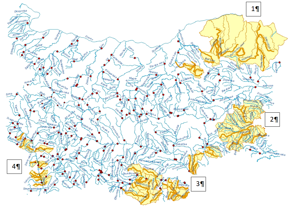
Fig. 1. Geographical distribution of drying rivers:
[1] - Dobrudja sinking rivers region; [2] - Southern Black sea region;
[3] - Eastern Rodopi region and Sakar; [4] - Struma watershed region
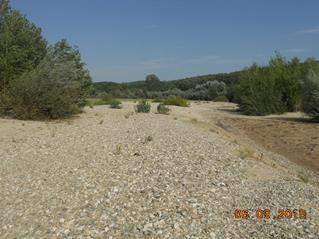
- Dobrudja sinking rivers region [1]
The Dobrudja rivers flow into the Dobrudja Plateau and parts of the Ludogorie area in wide or canyon-shaped river valleys. Humidity, cloudiness and rainfall in the region are less due to the very specific “rainfall shadow” which characterizes and distinguishes the region. This area is characterized by a small outflow coefficient of rainfall, one of the lowest determined on the territory of Bulgaria – only 2%.
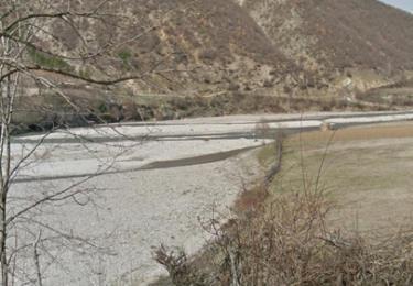
In the region of Dobrudja and Ludogorie are distributed mainly carbonate rocks (limestones with lower Cretaceous and Neogene age). These rocks form three main ground aquifers - the MalmValange, Barrem-Apt and Neogene (Sarmatian). Surface runoff is submerged in the all three horizons. Dobrudja area is characterized by negligible surface runoff and very large karst groundwater resources. The low rainfall and karst character of the area limits the surface runoff after prolonged heavy rainfall. Characteristic of the Dobrodzha rivers is the absence of a true estuary, submersion and groundwater feeding; truncated or unformed shallow river beds. The rivers are dry, with mainly ground feeding and most often large catchments with an altitude of less than 300 m.
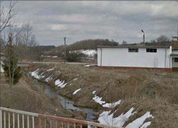
Kanakiol river Senkobetz river
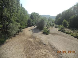
- Southern Black Sea region [2]
The rivers in the Southern Black Sea region form their runoff under the influence of the Mediterranean climate but with specific features of the Black Sea area.
The region is characterized by diverse geology. The northern part of the area is dominated by sedimentary rocks of Cretaceous, Paleogene and Neogene age. To the south, the terrains in the catchment areas of the small and medium-sized Black Sea rivers are made up mainly of silicate rocks (upper Cretaceous volcanics): andesite, tuff, tuffite; as well clays, sands, poorly soldered sandstones, marls, conglomerates and limestones.
Most of the region is characterized by the lack of significant aquifers. The specific Black Sea climatic influence and the lack of significant ground feeding are the main factors for the seasonal drying up of rivers in the region. The Southern Black Sea region is characterized by low water content with low runoff (11%). Typical for the region is the great diversity in the annual runoff distribution, which is strongly influenced by the nature of rainfall and their distribution over the years. There are years of prolonged drought due to low rainfall, as well as years of prolonged rainfall and significant river runoff that means the interannual flow distribution varies very much. This is illustrated in Figure 2 for the Fakia River.
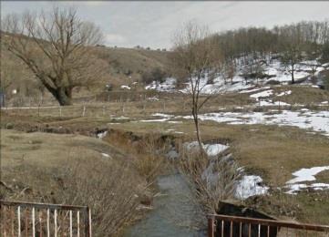
Otmanli river Aheloj river Sredetzka river
3. Eastern Rodopi and Sakar Mountains region [3]
The region covers the catchments of the rivers originating in the southeastern and northeastern part of the Rhodopi, Sakar and part of the southernmost tributaries of the Tundja River with springs in the Strandja Mountain.
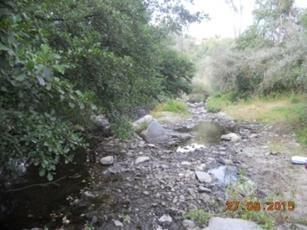
A specific river type for this region are the sub-Mediterranean small and medium-sized rivers, characteristic of all tributaries of the Arda River flowing into the section from the Kardzhali Reservoir to the border. The right tributaries of the Arda - Varbitsa and Krumovitsa Rivers are the special and very typical case of the sub-Mediterranean mountain rivers, characterized by rapid outflow concentration, formation of extreme high waves and severe shallow water afterward - Fig. 3. During periods of low water these rivers are in process of drying up or are in a state of entirely dry river beds. The specificity of the river types in the valley of the Arda River (main streamflow in the region) is determined by the morphostructure of the relief of the Arda valley (strongly indented by valley extensions) and the climatic characteristics with strong Mediterranean impacts.
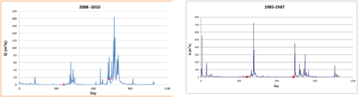
Fig. 2. Hydrograph of Fakijska river - Fig. 3. Hydrograph of Varbitza river -
Mediterranean impact in the Black Sea Mediterranean impact in the mountain area,
area - Region 2 Eastern Rodopi region and Sakar - Region 3
The catchment areas are composed mainly of silicate (magma and metamorphic) rocks:
southern Bulgarian granites, gneisses, shales, rhyolites, etc. The specified rock formations lack the conditions for the formation of significant resources from groundwater type cracks. In general, areas with the distribution of these rock formations are estimated to be poorly waterlogged. The Mediterranean climate, the lack of significant aquifers and the natural drainage of the terrain are the main factors for the observed seasonal dryness of these rivers and their torrential character.
The small left tributaries of the Maritza River, originating from the Sakar Mountains, are also attached to this region.
Uvadjik river | Tcham dere river | Elbasan dere river |
Biala reka river Luda reka river Hambar dere river
4. Struma watershed region [4]
Mediterranean influence on runoff formation (Continental-Mediterranean climatic region) covers the middle reaches of the Struma River, where drying, mostly small left and right tributaries have been observed, for example as the Lisiyska River, the Kamenitza River, the Zlina River, the Sedelska River, Rybnik, Sklavska River and more.
The catchment areas are composed mainly of silicate (magma and metamorphic) rocks:
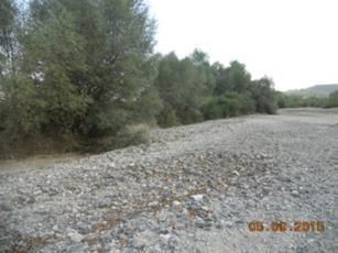
southern Bulgarian granites, gneisses, shales, rhyolites, etc. In the mentioned rock formations, there are no conditions for the formation of significant resources from groundwater type in the cracks. Generally, areas with the distribution of these rock formations are estimated to be poorly waterlogged. The Mediterranean climate, the lack of significant aquifers and the natural drainage of the terrain are the main factors for the observed seasonal drying up of these rivers and the torrential nature of some of them, such as the Potoka River and others (look at photos below).
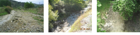
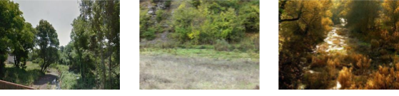
Suha reka river Ribnik river Voitcha river
The reasons for the drying up of the rivers in the four identified regions have different genesis. The regions located in the eastern part of the Rhodopi Mountains and the catchment area of the Struma river are exposed to the Mediterranean climate, which is reflected in hot and dry summers with little rainfall and prolonged drought. In the southern Black Sea region and the Strandja Mountains, there is a mixed influence of the Mediterranean climate and the specific influence of the Black Sea, characterized by wet winters and autumns and drier spring and summer. The genesis of the drying up of the rivers in Dobrogea is quite different. The main reason is the geological structure of the area and the sinking of the rivers in quaternary alluvial and diluvial deposits in the karst region. An acute continental climate with prolonged summer droughts is another important factor.
The following statistical characteristics are presented in the annexed Table 1 – n 0 is the total number of days with zero-flow, ƒ is the fraction of zero-flow years which is the number of years with zero-flow divided by the total number of years, ma is the mean annual number of zero-flow days which is the total number of zero-flow days divided by the number of years, max days – maximum number days zero-flows in the one year for the period, min days – minimum number days zero-flows in the one year for the period, mean days – mean number days zero-flows in the one year for the period, Cv – coefficient of variation of the days with zero-flow. The statistical characteristics in question cannot be considered as being fully representative for the regions since they only cover information from observed rivers. There are drying rivers that are not covered by regular hydrological monitoring or field observations. Nevertheless, the information presented below is indicative for the nature of the drying process in Bulgarian rivers.
On average per year, during the investigated period, the number of days with zero-flow days varies widely from 1 day to 200 days, with the smallest amplitude in Region 4 – from 4 to 23 days (Table 1). The annual registration (each year) of zero-flow days is observed only in the Eastern Rhodopi region, which as noted above, is characterized by sudden high waves followed by long periods of drought and the impact of Mediterranean climate is s.
In all other regions, there are no annual (or almost every year) entirely dry beds. They vary for different rivers, with the less frequent occurrences being recorded in the rivers in the catchment area of the Struma River. Also, in this region, dry rivers are only medium and small tributaries of the mainstream but never Struma River itself. They do not form distinct sub-regions but are scattered along the main river, mainly in its middle reaches. Usually they come from a lower altitude.
The Table 1 also shows the maximum, average and minimum number of days of drying for the considered period. No regularity is found in the recurrence of zero-flow days when they do not occur every year obviously it is a direct consequence of the meteorological situation in the respective year but depends on the geological condition at any catchment as well.
Table 1. Statistical characteristics at gauging stations with zero-flow daily data
Region | River | Location | n0 | ma | ƒ | max d | min d | mean d | Cv |
Region 1 | Kanagiol | Osenovez | 488 | 70 | 71 | 244 | 30 | 98 | 0.87 |
Senkovez | Golyamata voda | 439 | 12 | 11 | 141 | 63 | 110 | 0.30 | |
Zarzar | Golyam porovez | 2004 | 200 | 70 | 365 | 148 | 286 | 0.34 | |
Region 2 | Fakiiska | Fakia | 294 | 8 | 22 | 81 | 6 | 37 | 0.76 |
Fakiiska | Zidarevo | 349 | 9 | 24 | 76 | 11 | 39 | 0.43 | |
Ropotamo | Veselie | 114 | 3 | 12 | 48 | 9 | 28 | 0.73 | |
Aitoska | Kameno | 634 | 18 | 31 | 146 | 10 | 58 | 0.72 | |
Sredezka | Prohod | 561 | 20 | 25 | 143 | 9 | 80 | 0.59 | |
Hadjiiska | Rujiza | 42 | 5 | 44 | 17 | 8 | 11 | 0.40 | |
Provadiiska | D.Voinikovo | 1868 | 144 | 62 | 365 | 20 | 186 | 0.80 | |
Golyama Kamchia | Ticha | 74 | 2 | 3 | 48 | 26 | 37 | 0.42 | |
Kriva | Novi Pazar | 33 | 1 | 12 | 20 | 5 | 11 | 0.72 | |
Region 3 | Vurbiza | Vurli dol | 31 | 1 | 8 | 18 | 5 | 10 | 0.66 |
Vurbiza | Djebel | 62 | 2 | 8 | 45 | 2 | 21 | 1.07 | |
Gilemiza | Tatul | 256 | 51 | 80 | 140 | 24 | 64 | 0.81 | |
Byala | Dolno Lukovo | 815 | 22 | 41 | 119 | 22 | 63 | 0.44 | |
Skut | Nivnyani | 273 | 7 | 8 | 138 | 23 | 91 | 0.66 | |
Desna bara | Burzia | 45 | 2 | 7 | 31 | 14 | 23 | 0.53 | |
Veshtichka | Veshtiza | 232 | 6 | 16 | 85 | 6 | 39 | 0.87 | |
Ochushniza | Ochusha | 67 | 2 | 14 | 31 | 8 | 13 | 0.74 | |
Luda Yana | Sbor | 125 | 7 | 26 | 58 | 11 | 25 | 0.82 | |
Strelchenska | Strelcha | 167 | 5 | 8 | 112 | 23 | 56 | 0.88 | |
Devinska | Beglika | 1698 | 154 | 100 | 274 | 82 | 154 | 0.36 | |
Tenesdere | Giovren | 4470 | 179 | 93 | 290 | 48 | 179 | 0.35 | |
Fanos | Poibrene | 1371 | 152 | 100 | 188 | 91 | 152 | 0.19 | |
Venkovska | Venkovez | 185 | 19 | 60 | 77 | 1 | 31 | 0.98 | |
Byala | Kurtovo | 96 | 3 | 8 | 28 | 8 | 16 | 0.54 | |
Omurovska | Partizan | 825 | 83 | 60 | 272 | 45 | 138 | 0.61 | |
Chinardere | Dulbok Izvor | 47 | 5 | 5 | 40 | 7 | 24 | 0.99 | |
Sutliika | Rakitniza | 173 | 5 | 8 | 101 | 16 | 58 | 0.74 | |
Golyama | Svilengrad | 976 | 98 | 70 | 239 | 94 | 139 | 0.35 | |
Turiiska | Turia | 1347 | 36 | 70 | 112 | 8 | 52 | 0.61 | |
Marash | Lozenez | 295 | 30 | 40 | 144 | 7 | 74 | 0.96 | |
Region 4 | Rechiza | Vaksevo | 365 | 10 | 8 | 130 | 110 | 121 | 0.12 |
Bl. Bistriza | Slavovo | 157 | 4 | 14 | 38 | 15 | 31 | 0.51 | |
Bl. Bistriza | Blagoevgrad | 868 | 23 | 46 | 197 | 7 | 51 | 1.08 | |
Byala | Razlog | 566 | 22 | 15 | 164 | 99 | 142 | 0.21 | |
Accidentally zero-flow | |||||||||
Region 2 | Gospodarevska | Svetlina | 39 | 2 | 6 | - | - | - | - |
Region 4 | Gradevska | Gradevo | 16 | 0 | 3 | - | - | - | - |
Konska | Batanovzi | 23 | 1 | 3 | - | - | - | - | |
Sov. Bistriza | Gurlyano | 25 | 1 | 3 | - | - | - | - |
5. Flow regime in the four regions with drying rivers
There are presented hydrographs and flow duration curves at three selected characteristic rivers for the studied 1981-2017 and for a year with highest proportion of zero flows (in violet); and median in interquartile ranges between Q25 and Q75 (in blue shaded areas) and median (in red). The selected characteristic rivers are Fakijska at the Black see region, Senkovec at Dobrudja and Bistriza River at Struma watershed. The selected rivers have a different year with highest proportion of zero flows as follow – 2001 for Fakijska and Bistritza and 1987 for Sencovec. The hydrographs and flow duration curves demonstrate the very different flow regime and interannual distribution in the different geographical region.
Comparison of the hydrographs on the Black Sea rivers shows a strong decrease of runoff after the peak of the spring high flows and a visible increase of runoff in the autumn-winter period (only in this region). This is in fact the specific Black Sea influence on the Mediterranean climate of the area and the mixing of the two marine impacts. In the Dobrudja region, the river hydrographs have low amplitude of Q25-Q75 outflow variation, as well as the median, due to the geological and hydrogeological conditions mentioned above. They lead to the formation of low runoff feeding mainly the underground horizons but not surface water. In these rivers there is no pronounced high water and floods are very rare. In the catchment area of the Struma River, the internal distribution of the runoff has a pronounced peak of high water in spring and a sharp decline and a prolonged period of drought. For the year with the most days dry, the hydrograph retains the specifics of the area, but the outflow this year is below quantile Q25. On the Figures 4, 6 and 8 are shown the hydrographs for selected typical rivers in the Southern Black Sea region, Dobrudja and Struma watershed demonstrating different flow regimes.
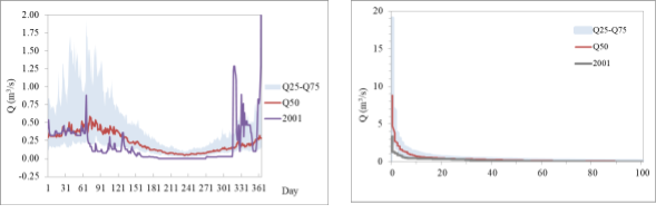
Fig. 4. Hydrographs of the Fakiiska River at Fakia – Fig. 5. Flow duration curves of the Fakiiska River
(1981-2017) Southern Black sea region at Fakia
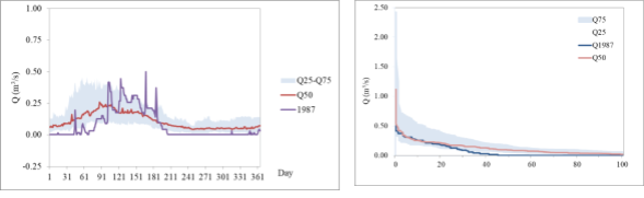
Fig. 6. Hydrographs of the Sencovez River – (1981-2017) Fig. 7. Flow duration curves of the Sencovez
Dobrudja sinking rivers region River
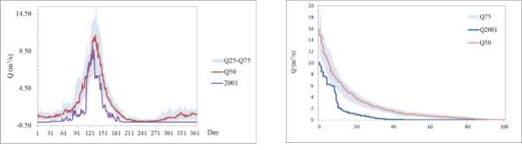
Fig. 8. Hydrographs of the Bl. Bistriza River – (1981-2017) Fig. 9. Flow duration curves
Struma watershed region of the Bl. Bistriza River
The presented flow duration curves (Figures 5, 7 and 9) confirm also the significant difference in the regime of the drying rivers in the different regions. The genesis of the drying of rivers is very different, which affects the durability of dry periods, as well as the dynamics of runoff change, especially when passing from wet to dry periods. The duration curves are important not only from an environmental point of view, but also from the point of view of water management, the use of water resources and the water consumption (Karagiozova et al., 2017, Ninov et al., 2017).
CONCLUSIONS
The present study reflects some of the results of the investigation on the spatial distribution, the genesis of drying up and the regime of the rivers with zero-flow days in Bulgaria. It combines statistical processing of available hydrological information for 42 gauging stations. Information from these hydrometric stations with registered zero-flow days and field survey in the frame of the various projects in the past is the base for the present study. For the first time, regions with dried beds are identified and mapped on the territory of the Bulgaria.
The current pioneering investigation for the country may be a good basis for future exploration of drying rivers. Areas with information on the existence of single drying rivers outside the monitoring network should be included in the survey in the future. The publication reflects the concerns of hydrologists in Bulgaria about deepening climate changes in the world and their impact on water resources.
REFERENCES
Agnieszka Rutkowska, Silvia Kohnová, Kazimierz Banasik, Jan Szolgay. Flow characteristics of intermittent rivers in Slovakia. Ann. Warsaw Univ. of Life Sci. – SGGW, Land Reclam. 2018. № 50(3). P. 215-227.
Belete Berhanu, Yilma Seleshi, Solomon S. Demisse and Assefa M. Melesse Flow Regime Classification and Hydrological Characterization: A Case Study of Ethiopian Rivers. Water 2015. 2015. Vol. 7(6). P. 3149-3165. https://doi.org/10.3390/w7063149
Eric Sauquet, Ilja van Meerveld, Cath Sefton, Francesc Gallart, Gregor Laaha, Atila Bezdan, Kazimierz Banasik, Anna Maria De Girolamo, Tobias Gauster, Tzviatka Karagiozova, Jurate Kriauciuniene, Plamen Ninov, Marzena Osuch, Simon Parry, Agnieszka Rutkowska, and Ourania Tzoraki. A catalogue of the representative European intermittent rivers. Geophysical Research Abstracts. 2019. Vol. 21, EGU2019-15026-5.
Ninov Pl. Karagiozova Tz., Rankova M. Water Resources Determination of Surface Water Bodies at the ulgarian basin of the Lower Danube. Journal of the Geographical Institute “Jovan Cvijić” SASA. 2017. Vol 67. No 1. Serbia.
Nick Bond1 and Peter Cottingham Ecology and hydrology of temporary streams: implications for sustainable water management. eWater Technical Report. eWater Cooperative Research Centre, Canberra. http://ewatercrc.com.au/reports/Bond_Cottingham-2008-Temporary_Streams.pdf.
Snelder T.H., T. Datry, N. Lamouroux, S.T. Larned, E. Sauquet, H. Pella, C. Catalogne. Regionalization of patterns of flow intermittence from gauging station records. Hydrol. Earth Syst. Sci. 2013. Vol. 17. P. 2685–2699. https://doi.org/10.5194/hess-17-2685-2013
Skoulikidis T.N., S. Sabater, T. Datry, M. Morais, A. Buffagni, et al. Non-perennial Mediterranean rivers in Europe: Status, pressures, and challenges for research and management. Science of the Total Environment, Elsevier, 2017. Vol. 577. P. 1-18. http://dx.doi.org/10.1016/j.scitotenv.2016.10.147
Tzviatka Karagiozova, Plamen Ninov - Determination of water resources in the national park Rila in the absence of a monitoring network. Electronic Book with full texts from XXVII Conference of the Danubian countries on Hydrological Forecasting and Hydrological bases of water management, Golden Sands, Bulgaria, 2017.
Thibault Datry, Gabriel Singer, Eric Sauquet, Didac Jorda-Capdevilla, Daniel Von Schiller, Rachel Subbington, Claire Magand, Petr Pařil, Marko Miliša, Vicenç Acuña, Maria Helena Alves, Bénédicte Augeard, Matthias Brunke, Núria Cid, Zoltán Csabai, Judy England, Jochen Froebrich, Phoebe Koundouri, Nicolas Lamouroux, Eugènia Martí, Manuela Morais, Antoni Munné, MichaelMutz, Vladimir Pesic, Ana Previšić, Arnaud Reynaud, Christopher Robinson, Jonathan Sadler,Nikos Skoulikidis, Benoit Terrier, Klement Tockner, David Vesely, Annamaria Zoppini. Science and Management of Intermittent Rivers and Ephemeral Streams (SMIRES). Research Ideas and Outcomes 3. 2017. P.e21774. DOI:10.3897/rio.3.e21774