MONITORING AND EVALUATION OF GROUNDWATER LEVELS
AT LADNÁ HYDROPEDOLOGICAL PROFILE
Hana Hornová, Ivana Černá
Czech Hydrometeorological Institute
Hana Hornová, CHMI, Kroftova 43, Brno, Czech Rep., hana.hornova@chmi.cz
Ivana Černá, CHMI, Kroftova 43, Brno, Czech Rep., ivana.cerna@chmi.cz
ABSTRACT
The planned construction of Oder-Danube canal was one of the largest activities, which led to the realization of research projects, which also included construction of boreholes for monitoring groundwater levels. Hydropedological profiles (HP) consist of boreholes, which are situated usually across the route of the canal and across longitudinal axis of valleys or flat Moravian hollows. They belong to basins of Oder, Bečva, Dyje (Thaya) and Morava rivers. First observations started back in 1933, subsequent followed after 1940. Nowadays these objects serve for obtaining general idea about the groundwater regime in valley profiles of these rivers. From geological perspective, these HP profiles are in an area of Quaternary sediments. Groundwater level monitoring at HP is important especially because of relating the profile to a particular watercourse and duration of the continuous monitoring. It can be used for determination of hydraulic link between surface water and groundwater. These values can be very useful especially in the determination of spread of potential groundwater pollutants via surface waters. Aim of the work is to assess course of groundwater levels at the Ladná profile of interest and to evaluate the effect of river engineering of the Dyje River on the groundwater regime, taking into account the drought period. Next aim of the work was to show the relationship with surface waters and evaluate the relationship between individual boreholes and the watercourse in the entire profile. In addition, long-term data series of groundwater level monitoring were used to perform evaluation of course of groundwater levels during various time periods, in particular during the individual reference periods, as specified by the CHMI, i.e. 1931-1960, 1931-1980 and the current reference period 1981-2010. Subsequently, the period 1991-2018 was also analyzed as a period associated with the current situation and finally also the entire period of monitoring, i.e. 1948-2018, a total of 70 years.
Keywords: groundwater, surface water, groundwater regime, quaternary sediments, hydraulic continuity
INTRODUCTION
Decreasing landscape retention ability in basins, river modifications, increasing demands for drinking water abstraction from surface and groundwater and more frequent occurrence of torrential rains lead to fluctuation of water regime in riparian forests of south Moravia and subsequent change in ecological conditions and reduced water availability for forest vegetation. Due to decreasing landscape retention ability there is a long-term increased run-off and associated disruption of water balance in landscape. Result of this is a decrease in groundwater reserves and also water sources in general. Strategic role of water lies especially in the field of food production, because 50-80% of water use is irrigation. Water availability is therefore becoming a global problem of the planet. It is likely that the Czech Republic will also face water availability problems in the future. Up to half of Czechs could be faced with potential water insufficiency, groundwater reserves are getting smaller. The entire problem of decreasing water reserves is caused by the overall effect of several major factors such as global climate change, irregular precipitation distribution throughout the year, undesired anthropogenic actions in landscape by farmers and water managers, which lead to decreased landscape retention ability, strategy for surface and groundwater abstraction, more frequent torrential rains, which due to fast run-off from the area via straightened river bed do not fill dams, lead to floods and landslides and associated damages and potential life losses. Expert prognosis is not very optimistic and groundwater reserves will be threatened, especially in spring. Recent significant drought periods in the Czech Republic occurred in 1982-1984, 1990-1995, 2003-2004 and the latest drought episode lasts up until now since 2014. The issue of drought is also very relevant for the region of South Moravia, in particular in water meadows of riparian forests.
Planned construction of Oder-Danube canal was one of the most significant actions, which led to realization of exploratory works, one of which was the construction of boreholes for monitoring groundwater levels. Since 1996 the area is protected for the prospective canalization of the Morava and Oder rivers and the route of the proposed Danube-Oder-Morava canal. This would also fulfil the original aim of monitoring long-term time series of groundwater levels. Hydropedological profiles (HP) consist of boreholes, which are situated usually across the route of the canal and across longitudinal axis of valleys or flat Moravian hollows. They are located on Oder, Bečva, Dyje (Thaya) and Morava rivers. First observations were between 1933 and 1934, additional were being added until 1940. Nowadays these objects are used for general understanding of groundwater regimes in valley profiles of these rivers. From geological perspective, these HP profiles are in an area of quaternary sediments. At the particular location of these profiles the soil types are predominantly light soils, sandy soils and slightly loamy and loose sands.
The studied Ladná profile is located above Břeclav and passes through the cadastral area of Charvatská Nová Ves and ends on the outskirts of the city of Lednice. Its total length is 4.98 km and crosses the rivers Dyje, Trkmanka and Včelínka. It was built in 1948, which means there is an almost 70-years long continuous monitoring series. Over the years the location underwent several changes, most important of which was the construction of the Nové Mlýny dam and modification of the Dyje river bed. Assessment of the hydropedological profile uses basic statistical methods used for large data set analysis. This includes analysis of dynamics of groundwater level in relation to surface runoff, precipitation and geological profile in various reference periods. The obtained findings from the individual reference periods are analyzed and thoroughly assessed. One of the assessed factors is the impact of drought in the period between 2014 and 2018 on the profile in relation to the distance from the watercourse and climatological conditions, including the effect on the overall historical series of groundwater level monitoring.
Aim of the work is to assess course of groundwater levels at the Ladná profile of interest and to evaluate the effect of river engineering of the Dyje River on the groundwater regime, taking into account dry periods. Next aim of the work was to demonstrate the relationship with surface waters and evaluate the relationship between individual boreholes and the watercourse in the entire profile. Two periods were selected for the evaluation of the effects of river engineering of the Dyje River on groundwater regime. First period, from 1948 to 1972, only deals with Dyje River engineering, i.e.
does not take into account the effect of the Nové Mlýny dam and the period from 1974 to 2018, i.e. after the construction of the Nové Mlýny dam and river engineering of Dyje in the stretch between Břeclav – Nové Mlýny. In addition, long-term data series of groundwater level monitoring were used to perform evaluation of the course of groundwater levels during various time periods, in particular during the individual reference periods, as specified by the CHMI, i.e. 1931-1960, 1931-1980, 19611990 and the current reference period 1981-2010. Subsequently, the period 1991-2018 was also analyzed as a period associated with the current situation and finally also the entire period of monitoring, i.e. 1948-2018, a total of 70 years.
METHODS AND DATA
The area of interest underwent significant changes in land use in the second half of the 20th century as a result of the construction of the Nové Mlýny reservoir. This meant that the total water area saw a largest increase from the original 2.01 % to 24.90 % of the total surface area (12618.37 ha). In 1960, largest water bodies were the restored ponds Strachotínský and Šakvický. Šakvický pond at Štínkovka became completely part of the lower Nové Mlýny reservoir. The Strachotínský pond remained partially delimited, but is in fact also mostly part of the central section of the reservoir. Main watercourses were Dyje, Svratka and Jihlava. The confluence of Svratka and Jihlava and river beds were artificially modified already in 1960. Also the Dyje river channel is regulated down to Dolní Věstonice. Significant ratio of these water bodies is represented by a large number of small pools – abandoned river beds and oxbow lakes along Dyje and Jihlava rivers, existence of which allowed hydraulic connection with the main channel of Dyje and Jihlava, as well as frequent outflow of these rivers. There were 133 water bodies in total in 1960. Practically all these pools became part of the current reservoirs. Water area in 2019 mostly consists of flooded areas of the Nové Mlýny reservoir and associated constructions. Following the change in water management conditions, only few watercourses in the area of interest remained that have their channel in its original position. They are 4 streams that had their channel modified already in 1960 – Dunajovický stream, Klentnický stream, Popický stream and Štínkovka. End sections of these streams are now shorter and became part of the current Nové Mlýny reservoir. At the end of the Klentnický stream water passes through a drainage canal along the lower part of the reservoir down to the dam, where it flows into the Dyje river. Popický stream and Štínkovka end in small water management objects, where the water is pumped to the lower part of the reservoir. Position of the Jihlava and Svratka confluence remained intact. Only the lower part of Svratka and the channels of both rivers were modified (extended embankment). All newly created small streams are related to the overall water management modifications of South Moravia. The entire Nové Mlýny reservoir is surrounded by drainage canals, which collect water soaked from the reservoir. One entirely new irrigation channel is the BrodBulhary-Valtice channel. From the central part of the reservoir, water is pumped approximately 700m over the ridge of Dunajovické hills from where it flows southeast by gravity via Dolní Dunajovice and further in the direction of Mikulov and Valtice.
Back in 1960, a significant ratio of the total area of interest consisted of permanently wet water meadows (3.14%). Usually this meant a number of small water bodies often surrounding the above-mentioned abandoned river channels (163 individual wetland areas). Two wetlands are larger – one lies between Strachotín and Šakvice, the other one is situated northwest of Nové Mlýny on the right bank of the Dyje River. However, in 2018 permanently wet meadows only represent the least frequent category (0.24 %) and are only found close to the banks of the Nové Mlýny reservoir. Also, the total area of the forest category decreased in the area of interest, from 13.65% down to 7.46% of the total area. Most of this decrease is caused by logging of the alluvial forests and subsequent flooding of these areas. Part of the former forested area is now arable land and also the forest islands west of Pasohlávky transformed into agricultural land. Decrease of forested area is partially compensated by an extension of forests in the area of Pavlovské and Dunajovické hills. Small forested areas were also created southeast of Brod nad Dyjí.
Change in hydraulic relationships in rock environment also affected groundwater. Embankment prevented floods in the alluvial areas and thus also prevented soaking into groundwater and increasing groundwater levels. Most scientific studies prove decrease of maximum groundwater levels and shorter duration of these maxima. A floodplain is affected by water regime of the particular watercourse as well as rock type, terrain, soil type and climate in the entire basin. Floodplain is therefore not just a product of a particular watercourse, but reflects state of the entire basin. This broader concept of floodplain is well described by the following characteristic: “Floodplains are very specific environments, completely different, or even in contrast with other landscapes. They form an axis, an aorta of landscape. They reflect development, life and history of the entire basin. Plains are never autonomous parts of the Earth, their evolution is affected by all parts of landscape, even by mountain forests in distant water divide. Anything that is taken away from the basin, what is washed away, enriches the floodplains…. Floodplains always form the highways for matter transport in landscape, highways for the spread of fauna and flora. Axis of a floodplain is always a watercourse, a river. It is the character of this river that is always crucial for the appearance of a floodplain, its child…” (Culek, 1992). Based on Prach (2003), the uniqueness of floodplains lies especially in the following properties. Energy, matter and information flows in floodplains are very fast and are of an open nature. For a specific ecosystem in floodplain, inputs and outputs (energy, nutrients, information) can many times exceed their transport within the ecosystem. Floodplains are characterized by high temporal-spatial heterogeneity. Floodplain ecosystems show a high productivity.
The Dyje basin is a very large area of over 13 419 km2 and watercourse length of 306 km. Czech Hydrometeorological Institute has 6 stations measuring surface water levels of Dyje – Podhradí, Vranov-Hamry, Znojmo, Trávní Dvůr, Nové Mlýny and Ladná. It operates 25 boreholes for monitoring groundwater levels and also small-diameter hydropedological boreholes, the so-called HP profiles – a unique feature only found in South and North Moravia.
They were created as a result of the Oder-Danube channel construction project. Preparation of this project brought about realization of many exploratory works, including construction of probes for monitoring groundwater levels. These were positioned in lines – profiles, which were labeled as hydropedological. They were usually situated across the route of the channel and also across the longitudinal axis of the valley or plain Moravian valleys. They can be found in the basins of Oder, Bečva, Dyje and Morava. First observations were made between 1933 and 1934, additional were being added until 1940. Nowadays these objects are used for obtaining general understanding of groundwater regimes in valley profiles of these rivers. In South Moravia they are currently aggregated into 4 units – HP0262 Podovín-Lednice, HP0263 Ladná-Charvatská Nová Ves, HP0266 Nové Mlýny and HP0267 Šakvice. Currently, groundwater levels are being monitored using automated devices at a total of 29 boreholes and one staff gauge on the Ladná-Charvatská Nová Ves profile. Originally there were 53 boreholes and 8 staff gauges on these profiles. The HP0266 Nové Mlýny profile was mostly flooded as a result of the construction of the Nové Mlýny reservoir and only 2 boreholes remained. Other profiles were reduced as a result of the need to reduce costs associated with operation of the monitoring network. Given the extent of the Dyje basin and the number of boreholes available in this area, it is not possible to concentrate on the entire area. Detailed analysis was therefore performed for the area near Břeclav, in particular the HP0263 Ladná-Charvatská Nová Ves profile, which is typical for the Dyje floodplains and has most boreholes directly linked to the surface station on the Dyje River.
Břeclav lies on the Dyje River and is surrounded by forests from three sides. Riparian forests lining the Dyje and Morava river represent an area of over 3500 ha, making it the largest complex of its kind in central Europe. Forests full of channel networks, oxbow lakes and pools were added to the list of Ramsar Convention in 1993 as “Mokřady dolního toku Dyje” (Wetlands of lower Dyje). Northwest of Břeclav lies Kančí obora (Kančí game preserve), a riparian forest with predominance of common oak and narrow-leafed ash. South of Břeclav is the most extensive complex of riparian forests, extending to the confluence of Dyje and Morava, with partially preserved riparian meadows and alluvial pools. This area is one of the most valuable areas of the primary forest reserve Ranšpurk and Cahnov – Soutok. On the west is the southeastern edge of the national natural reserve Lednické rybníky (Lednice ponds).
Two periods were selected for the evaluation of the effects of water management and engineering on groundwater regime. First the period between 1948 and 1972, only in terms of Dyje, i.e. without the effects of reservoirs close to Nové Mlýny. Second, the period from 1974 to 2018, i.e. after the construction of the Nové Mlýny dam and modification of Dyje in the section between Břeclav and Nové Mlýny. In the meantime, based on long-term time series of groundwater levels, an assessment of the course of groundwater levels for several time periods was made – in particular for the individual reference periods as they were proposed by the CHMI (1931-1960, 1931-1980 and the current reference period 1981-2010). In addition, the period between 1991 and 2018 was also analyzed as a representation of the current situation. The entire period of 70 years cannot be assessed because of the Nové Mlýny dam construction.
Evaluation of the relationship between groundwater and surface water was performed using knowledge of average monthly flow rates for Dyje during the period of interest. Data was used from surface stations Dolní Věstonice (Nov 1948 to Oct 1988), the next downstream station Nové Mlýny below the dam (Nov 1988 to Dec 1994) and data from the Ladná station, which lies directly in the HP profile and has been monitored since Nov 1987 until now. Last station used for the assessment was the station Břeclav-železniční most (Břeclav – train bridge), where flow rates were analyzed in the period between Nov 1965 and Oct 1987. The Ladná station replaced the Břeclav-železniční most station, which stopped operating on Nov 1, 1987 and was used to derive flow rates also for the station Nové Mlýny in the period 11/1988 to 10/1994. Not all water was present in the station Břeclav – žel. most during flow rates exceeding 350 m3.s-1, because the channel does not have a sufficient capacity. Such higher flow rates were distributed by a weir on the outskirts of Břeclav away from the main watercourse channel to a discharge branch, which flows back to the main channel below the station.
Based on a hydrological map one can see that Ladenský profile is a fluvial sand-clay sediment with occasional boulders (flood gravel) and sediments of artificial water bodies, deluvio-fluvial sandy sediments (between Ladná and Charvatská Nová Ves) and fluvial sandy gravel (directly in Ladná and Charvatská Nová Ves). Ladenský profile boreholes belong to the hydrogeological region 1652, which includes quaternary fluvial sediments of the Dyje River. Groundwater level is free. Sediments of the floodplain belong to a structure of fissure groundwater with a characteristic hydrogeological link with surface flow. From the geological perspective the profile has the following structure (Fig. 1): dominant are sandy clays in the highest layers, followed by predominantly clay sand with a depth up to 0.9 m. Deepest layers are mostly sand gravel. Layer of clay soils is not present in the hydropedological profile at all, occasionally one can find clay sand soil or clay sand.
DEPTH OF GEOLOGICAL LAYER FROM THE TERRAIN [m] | ||||||||
1 | KB0689 | 0,0-0,4 loamy sand soil | 4,6-6,7 incoherent sand-gravel | 0,4-1,3 | clay sand | 1,3-2,3 medium-grained sand | 2,3-4,6 | sandy-dusty clay |
2 | KB0690 | 0,0-0,5 sandy clay | 3,9-5,9 dusty clay | 0,5-2,7 | clay sand | 2,7-3,2 dusty clay | 3,2-3,9 | dusty clay with sand |
3 | KB0691 | 0,0-0,5 sandy clay | 0,5-2,1 clay-sand soil | 2,1-2,9 | clay with gravel | 2,9-4,6 sand gravel | ||
4 | KB0692 | 0,0-0,5 sandy clay | 0,5-2,7 clay sand | 2,7-5,6 | sand gravel | |||
5 | KB0693 | 0,0-0,7 sandy clay | 0,7-2,2 clay sand | 2,2-4,6 | sand gravel | |||
6 | KB0694 | 0,0-1,0 sandy clay | 3,8-5,7 sand-gravel | 1,0-2,5 | loamy sand soil | 2,5-3,1 clay sand | 3,1-3,8 non-clay gravel sand | |
7 | KB0695 | 0,0-0,8 sandy clay | 0,8-2,2 clay sand | 2,2-6,1 | sand gravel | |||
8 | KB0696 | 0,0-0,7 sandy clay | 0,7-1,5 dusty clay | 1,5-2,3 | clay sand | 2,3-5,4 sand gravel | ||
9 | KB0697 | 0,0-1,7 loamy sand soil | 1,7-2,3 clay sand | 2,3-5,9 | sand gravel | |||
10 | KB0698 | 0,0-1,6 clayey soil | 1,6-2,5 clay sand | 2,5-4,6 | sand gravel | 4,6-5,2 loamy sand soil | ||
11 | KB0699 | 0,0-2,1 clayey soil | 2,1-3,1 loamy sand soil | 3,1-5,1 | gravel sand | |||
12 | KB0700 | 0,0-0,7 mica clay | 3,5-5,6 sand | 0,7-1,6 | loamy sand soil | 1,6-2,5 clay-sandy soil | 2,5-3,5 clayey-dusty soil | |
13 | KB0701 | 0,0-0,6 mica clay | 0,6-1,5 loamy sand soil | 1,5-4,2 | sand gravel | |||
14 | KB0703 | 0,0-0,8 clay sand | 0,8-2,5 loamy sand soil | 2,5-3,1 | sand | 3,1-5,9 sand gravel | ||
15 | KB0704 | 0,0-2,3 mica clay | 2,3-3,1 sand | 3,1-5,8 | sand gravel | |||
16 | KB0705 | 0,0-0,8 heavily clay sand | 3,6-6,4 clayey sand-gravel | 0,8-1,5 | mica clay | 1,5-2,6 sandy-dusty clay | 2,6-3,6 coarse grained sand | |
17 | KB0706 | 0,0-1,4 sandy-dust soil | 4,1-5,7 medium-grained sand | 1,4-2,3 | dust soil | 2,3-3,4 sandy soil | 3,4-4,1 clay sand | |
18 | KB0707 | 0,0-1,0 sandy-dust soil | 1,0-2,1 loamy sand soil | 2,1 - 5,1 medium-grained sand | ||||
19 | KB0708 | 0,0-1,4 clay-sandy soil | 1,4-2,5 clayey soil | 2,5-3,6 | clay sand | 3,6-5,8 sand gravel | ||
20 | KB0710 | 0,0-0,8 clay-sandy soil | 2,5-5,2 sand gravel | 0,8-1,7 | sandy clay | 1,7-2,1 clay sand | 2,1-2,5 clay sand | |
21 | KB0711 | 0,0-1,0 sandy clay | 1,0-2,3 clay sand | 2,3-5,3 | sand gravel | |||
22 | KB0712 | 0,0-0,6 clay with gravel | 0,6-1,7 clay sand | 1,7-5,4 | sand gravel | |||
23 | KB0714 | 0,0-1,9 clay sand | 1,9-6,1 sand gravel | |||||
24 | KB0715 | 0,0-0,5 sand-dust vlay | 0,5-1,3 dusty clay | 1,3-2,4 | sand gravel | 2,4-5,2 sand | ||
25 | KB0716 | 0,0-2,4 loamy sand soil | 2,4-2,7 sand | 2,7-5,8 | clay sand | 5,8-6,5 dusty clay | ||
26 | KB0717 | 0,0-0,8 loamy sand soil | 0,8-2,4 loamy-dust-sandy soil | 2,4-6,5 | sand gravel | |||
27 | KB0718 | 0,0-1,8 clay sand | 1,8-5,3 gravel sand |
| ||||
28 | KB0719 | 0,0-2,4 clay-dust soil | 2,4-5,4 sand gravel | |||||
Fig. 1. Geological profile
The original profile had 28 probes, after several changes it now has 25 probes, out of which a total of 16 probes now has automated systems with daily measurements and one staff gauge, surface station Ladná nad Dyjí, which lies on the profile axis (Fig. 2). Groundwater levels are being monitored since 1948. There are three watercourses crossing the profile – Dyje, Ladenská strouha and the left tributary Včelínek.
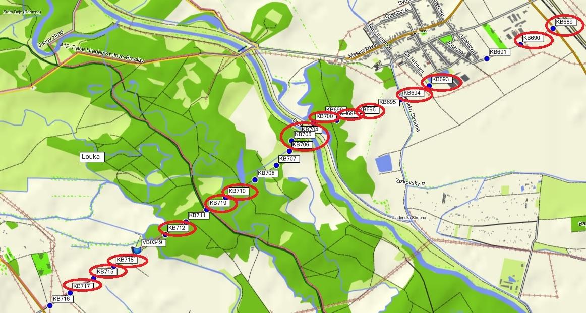
Fig. 2. Monitored probes as of 2019
In 1949, the hydropedological profile had a total length of 4986.4 m, with an average elevation of 160.46 m above sea level (Fig. 3).
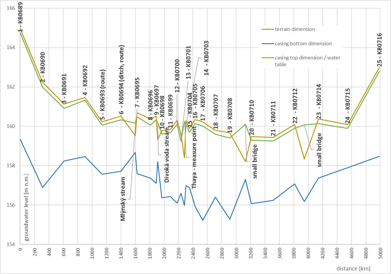
Fig. 3. Horizontal profile HP0263 Ladná – Charvatská Nová Ves
In 1962 three new probes were added, in particular the probes KB0717 and KB0718 between the probes KB0714-KB0716, because these two were quite far apart from each other (approximately 300 m). The probe KB0719 was added between the probes KB0710 and KB0711. In 1963 the entire profile was redrilled, in 1980s and 1990s the probes were deslimed and cleaned. In 1969 monitoring ended at the KB0703 probe, because it was destroyed. In 1970 the same happened to the probe KB0701. In 1975 also the KB0697 was destroyed and in 2005 two other boreholes – KB0692 and KB0714. In 2010 the monitoring network was reduced, 16 currently operating probes were chosen, which were equipped with automated devices in 2012, with hourly groundwater level data. The remaining probes are not currently being monitored, but in the future, it is planned to include them in the network again. The last probe that stopped operating was the KB0691 probe, because it had to be removed in 2018 as it stood where houses were to be built.
The KB0702 probe indicated the staff gauge on Dyje, which was in operation from 1948 to 1982. However, water at the gauge often froze, data was not available due to deposits carried by the river and the data is therefore incomplete (Fig. 4). In 1982 it was replaced by a staff gauge at the surface station, originally at the station Břeclav – žel. most, then directly in Ladná, where the profile is located.
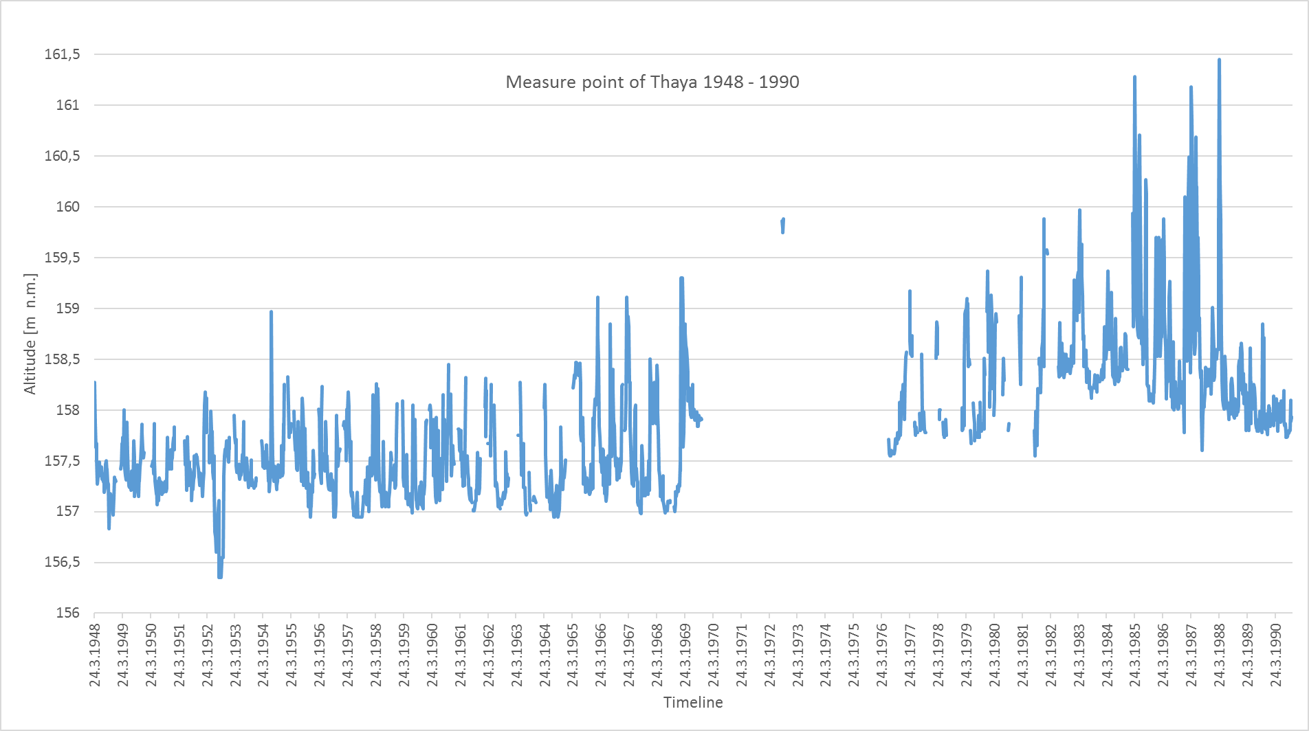
Fig. 4. Measurements from the KB0702 staff gauge between 1948 and 1982
In order to assess groundwater regime in relation to surface waters it is also important to know the occurrence of critical years in terms of hydrology and climatology (Fig. 5). First dry year in the period 1900-2018 was the year 1912. The year 1914 was characterized by highest daily maximum precipitation. Average maximum across all stations in South Moravia was 64 mm. First half of the 20th century was variable, without significant extremes. Driest period were the years 1931-1935 then followed by floods in 1938. Also 1942 was a very dry year, especially in Bohemia, followed by another relatively dry year 1943. Year 1947 saw a catastrophic drought (between April and September, monthly precipitation amounts only ranged between a few mm and approximately 20 mm). Beginning of the 1950s was also variable, in 1954 there were floods on Vltava (Bohemia), which almost destroyed the Slapy dam, which was in construction at that time. Water in the reservoir overflew and the dam was not yet completely finished. The year 1959 had the longest dry period, i.e. most consecutive days without rain. There was no rain in the entire Czechoslovakia in August, September, October and first week of November. Years 1961-1964 were also dry, in 1964 tree leaves in Vysočina turned yellow already in August. Next year, in 1965, the Great Rye Island (SW Slovakia) was flooded, southeast part of the republic was also affected, especially the Morava basin, where the Vranov reservoir overflew. Another dry period occurred between 1971 and 1974, with the exception of Vysočina, where June and beginning of July were wet. The year 1975 was rather wet, however it was followed by another dry year in 1976 – in South Moravia, corn and beet grew “like telegraph posts – 25 m apart”. It then rained in July and the dormant seeds germinated leading to problems with harvest. Dry years were also 1982-1984, with a significant windstorm in the summer of 1984, which caused significant damages in the forests around Velké Meziříčí. At some places not a single tree remained standing. As can be seen, drought episodes are encountered approximately every 10 years, which is also proved by dry years 1990-1995, after which catastrophic floods occurred in 1997. Another flood occurred in 2002, followed by a dry year 2003 and 2007. Floods were also encountered in 2006. In 2010 there were heavy rain episodes in Moravia, making it the second wettest year since 1900, 1941 being the wettest. Year 2012 was again rather dry, in 2013 there were floods in Bohemia as a result of strong thunderstorms. Since 2014 until now there is another episode of drought.
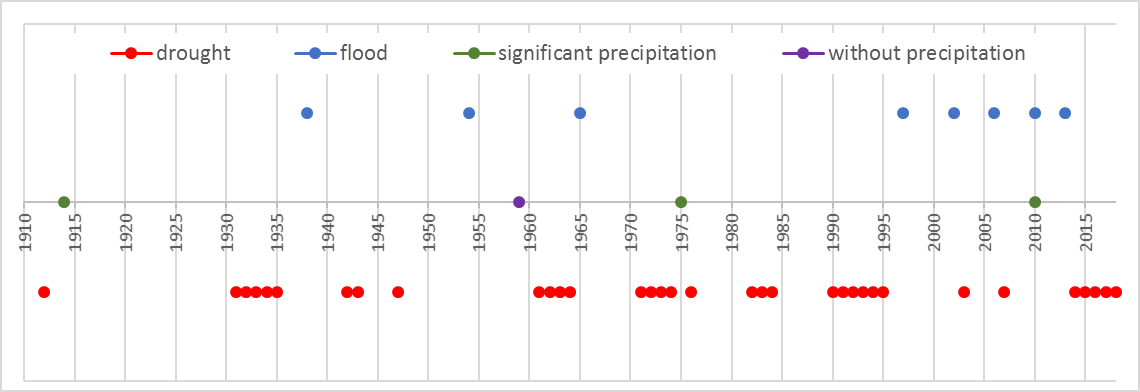
Fig. 5. Critical years from the perspective of drought and floods
RESULTS AND DISCUSSION
Four probes were selected to assess the effect of water management modifications at Dyje River and interactions with surface waters, in particular the KB0689, KB0706 probes in operation since 1948 and probes KB0718 and KB0719, which operate since 1962. Their location in the profile and distance from one another is given in Fig. 6. The probe KB0689 lies 2.3 km away from Dyje on the edge of a field, the probe KB0706 is closer to the watercourse (0.2 km), in a dense riparian forest. KB0719 probe is 1.1 km far from the river in a forest and KB0718 is 2 km from Dyje, on a field in a close vicinity to a newly constructed pond.
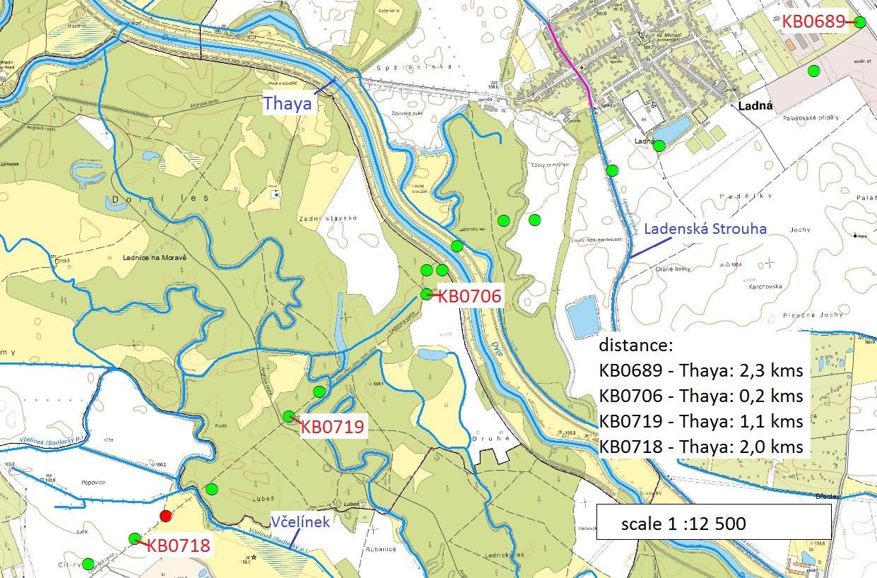
Fig. 6. Location of assessed probes in profile
For each of the probes, the following data was evaluated: long-term averages, minima and maxima for the periods 1931-1960, 1931-1980, 1981-2010 (current reference period) and 1991-2018. Then, for each probe a drought threshold was determined, which represents 85 % of long-term monthly cumulative frequency curve (hereafter DMKP). Graphs then show monthly course of groundwater level elevation in the probe, together with flowrates of Dyje as measured by surface gauges, in particular at the stations Dolní Věstonice, Nové Mlýny below dam, Ladná and Břeclav – železniční most.
The KB0689 probe is 6.7 m deep with 0.0-0.4 m loamy sand soil, 0.4-1.3 m clay sand, 1.32.3 m medium-grained sand, 2.3-4.6 m sandy-dusty clay and 4.6-6.7 m incoherent sand-gravel. Elevation of the profile is 164.13 m a. s. l. Over the entire period of monitoring, i.e. since 1948, there was a continuous measurement. In 1959 the borehole dried up for the entire year, as well as in 19751976 (Fig. 7).
Based on the assessment there is a significant decrease in groundwater level during the period of construction of the Nové Mlýny reservoir and monitoring was interrupted by drought in 19751976. Another reason for the decrease of groundwater could be soil amelioration at the beginning of 1980s. The probe is situated on a field and it is possible that the course of groundwater level is affected by the amelioration work. Prior to the construction of the Nové Mlýny reservoir there are obvious 10-year periods, which were disrupted by the Nové Mlýny dam construction and have not stabilized until today. From the perspective of the individual reference periods, all the periods are comparable in terms of average groundwater level. When looking at the variability, i.e. the minima and maxima in the individual periods, the least variable is the period 1931-1960 (more precisely 1948-1960 – beginning of measurement), when the difference was only 1.36 m. In contrast, the most variable levels were seen in the period 1981-2010, 2.73 m. In the period 1931-1980 it was 2.26 m and in 1991-2018 2.05 m. Most significant change in terms of minimum groundwater level can be seen between the period 1931-1960 and the period 1931-1980, where the long-term minimum level decreased by 1.16 m. In contrast, in 1991-2018 the long-term minimum increased compared to 1981-2010 by 0.52 m. Significant change between long-term maximum is between 1931-1980 and 1981-2010, when the maximum increased by 0.6 m. From the perspective of long-term drought threshold, i.e. 85% of long-term cumulative frequency curve, one can see a decrease in groundwater level between the period 1931-1960 and 1931-1981 by 0.82 m, since 1931-1980 the drought threshold constantly increases, first by 0.28 m (1981-2010), subsequently by 0.34 m (1991-2018).
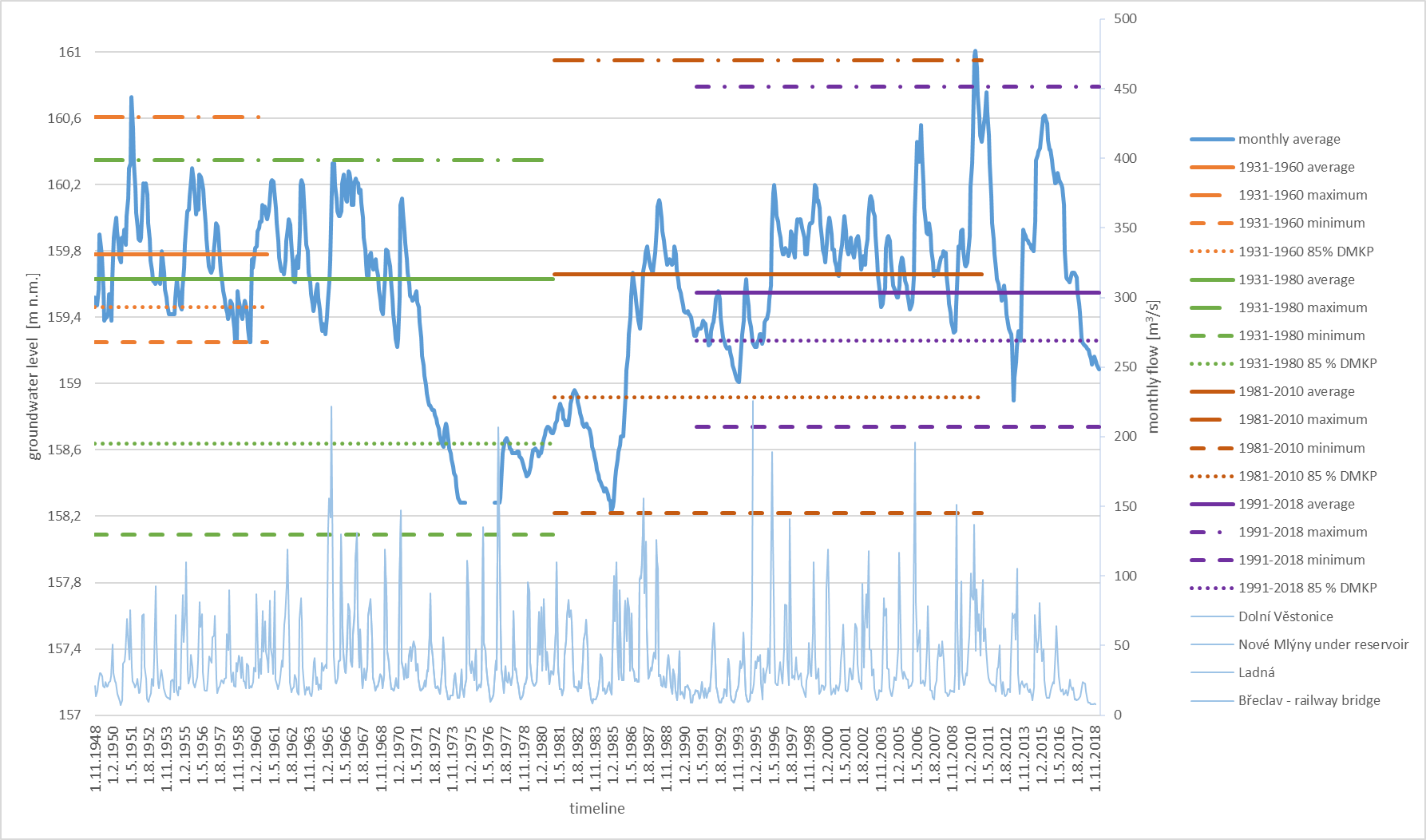
Fig. 7. KB0689 probe assessment
Periodicity of annual course of levels has in recent years been very disrupted, mostly by the effect of the very dry years 2014-2018.
The KB0706 probe is 5.7 m deep. 0.0-1.4 m is sandy-dust soil, 1.4-2.3 m is dust soil, 2.33.4 m is sandy soil, 3.4-4.1 m is clay sand, 4.1-5.7 is medium-grained sand. The probe is located at an elevation of 159.74 m a. s. l. There is a continuous data series available since 1948, in November 1988 a continuously operated water pump has been installed for waterworks in Břeclav.
Data analysis (Fig. 8) shows a significant decrease in groundwater level at the time when the pump was installed close to the probe. This pumping affected the borehole significantly until 1997, when the values stabilized at the original values observed prior to the pumping again, however, are still lower than the levels observed before the construction of the Nové Mlýny dam. It can be seen that this construction affected the groundwater levels, however, in a lesser extent than the KB0689 probe, because the KB0706 probe is in a close vicinity to the Dyje River and corresponds to the flow rate of surface water. From the perspective of the individual reference periods, all the periods are comparable with regards to the average groundwater level, with the exception of the period 19812010, when long-term average decreased by 0.2 m. Regarding the maximum and minimum levels, i.e. the overall borehole groundwater level variability, the most variable was the period 1931-1960 (more precisely 1948-1960 – beginning of measurement), where the groundwater level variability was 2.72 m. Least variability of groundwater levels was observed in the period 1931-1980 and 19912018, 2.33 m. In the reference period 1981-2010 the groundwater level variability was 2.47 m. Most significant change with respect to minimum groundwater levels was between the period 1931-1960 and 1931-1980, when the long-term minimum level decreased by 0.43 m, other periods are comparable. Significant change in long-term maxima can be seen between the periods 1931-1960 and 1931 and 1980, when there was a decrease by 0.43 m and in the subsequent period 1981-2010 by a further 0.3 m. From the perspective of long-term drought threshold, i.e. 85 % of long-term cumulative frequency curve, one can see a decrease between the periods 1931-1960 and 1931-1980 by 0.2 m, with a decreasing trend in the subsequent period – in 1981-2010 a decrease by 0.32 m. Increase in the drought threshold was observed in the period 1991-2018, when the threshold increased by 0.37 m. Also, in this case there is an obvious disruption of annual groundwater level regime, especially due to the very dry years 2014-2018.
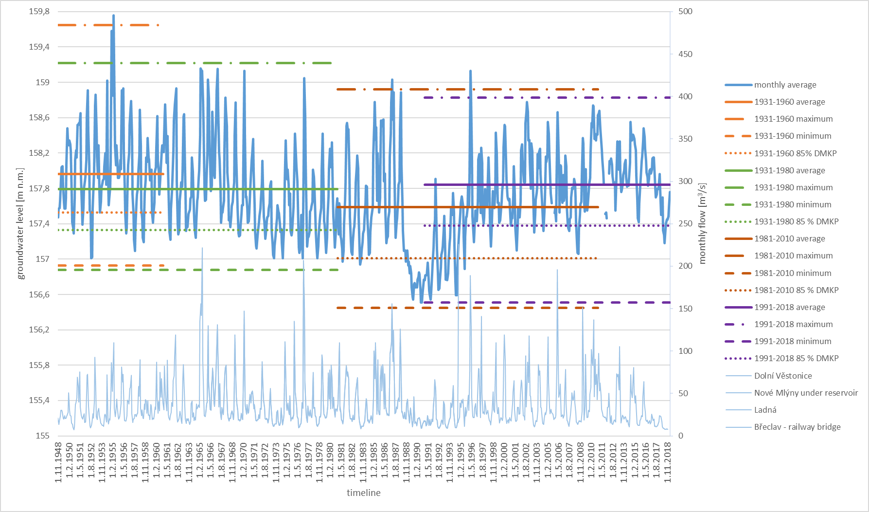
Fig. 8. KB0706 probe assessment
The KB0719 probe is 5.8 m deep, with 0.0-2.4 m clay-dust soil and 2.4-5.8 m sand gravel. It is situated at an elevation of 159.23 m a. s. l. There is a continuous monitoring since 1962, in 1997 the borehole was redrilled after a flood and deslimed in 1985 and 2006. After the construction of the Nové Mlýny dam, a riparian forest drainage canal has been constructed close to the borehole, which is constantly full of surface water.
Data analysis (Fig. 9) shows an obvious decrease in groundwater level after the construction of the Nové Mlýny dam and before the water management modifications. As a result of a drainage canal, however, there is a permanent increase in groundwater levels. From the perspective of the reference periods there is an obvious increase in groundwater levels. Between the period 1931-1980 (more precisely 1962-1980 – beginning of measurement) and the period 1981-2010 there is an increase in long-term average groundwater level by 0.38 m, in the subsequent period by a further 0.19 m. Following the construction of the Nové Mlýny dam there is a larger variability in the groundwater levels, in the period 1981-2010 it was 2.38 m, in the current period (1991-2018) it is 1.98 m. Most significant change in terms of minimum groundwater levels is between the period 19311980 and 1981-2010, when there is a decrease by 0.39 m, but in the subsequent period (1991-2018) the long-term minimum increased by 0.45 m, i.e. by 0.06 m compared to the period 1931-1980. There is no significant difference between the individual periods in terms of long-term maximum levels. Regarding the long-term drought threshold, i.e. 85 % of cumulative frequency curve, one can see increasing trend, where the threshold increased by 0.2 m between 1931-1980 and 1981-2010 and by a further 0.33 m in 1991-2018. Periodicity of the annual groundwater regime is also quite disrupted in recent years, especially by the effect of the dry years 2014-2018 and the associated decreasing trend.
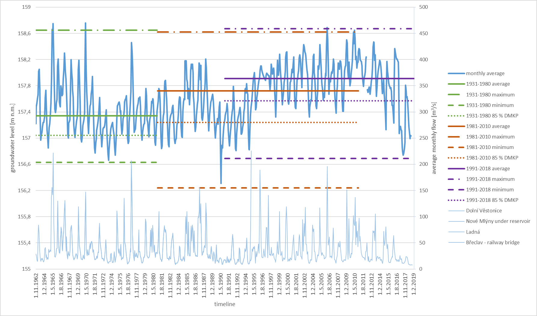
Fig. 9. KB0719 probe assessment
The KB0718 probe is 5.3 m deep with 0.0-1.8 m clay sand and 1.8-5.3 m gravel sand. It is located at an elevation of 160.15 m a. s. l. There is a continuous monitoring since 1962 and the borehole was redrilled in 1997 after it was flooded.
Data analysis (Fig. 10) very well illustrates the dry periods, which repeat approximately every ten years. As a result of the Nové Mlýny dam construction there was a significant decrease in groundwater levels, which is also obvious from the long-term characteristics of the individual periods. There is no other significant watercourse nearby apart from Dyje, it is therefore fully dependent on surface water inflow and precipitation. Groundwater levels correspond to the Dyje River levels, during the period of Nové Mlýny dam construction this relationship between surface and groundwater levels was disrupted. From the perspective of the individual reference periods they are all comparable in terms of average groundwater levels, with a slight increase in the 1981-2010 period by 0.09 m. Regarding minimum and maximum levels, i.e. the overall variability, the most variable periods are the periods 1981-2010 and 1991-2018, when the variability in minimum and maximum level was 1.53 m. In contrast, least variability in groundwater levels was observed in the period 1931-1980, 1.42 m. Differences between long-term minima are also very small, in the period 1981-2010 the minimum increased by 0.09 m, in the subsequent period it was constant. With regards to the longterm drought threshold, i.e. 85 % of long-term cumulative frequency curve, there were no significant changes over the entire period of monitoring, in the period 1981-2010 the long-term threshold of DMKP increased by 0.08 m, in 1991-2018 by a further 0.05 m. More significant are the changes in long-term maximum, where there is an increase by 0.21 m in the period 1981-2010. Periodicity of annual groundwater level course has not recently been as disrupted as in the case of other probes, however the dry period 2014-2018 also significantly affects the probe and there is a decrease in groundwater levels.
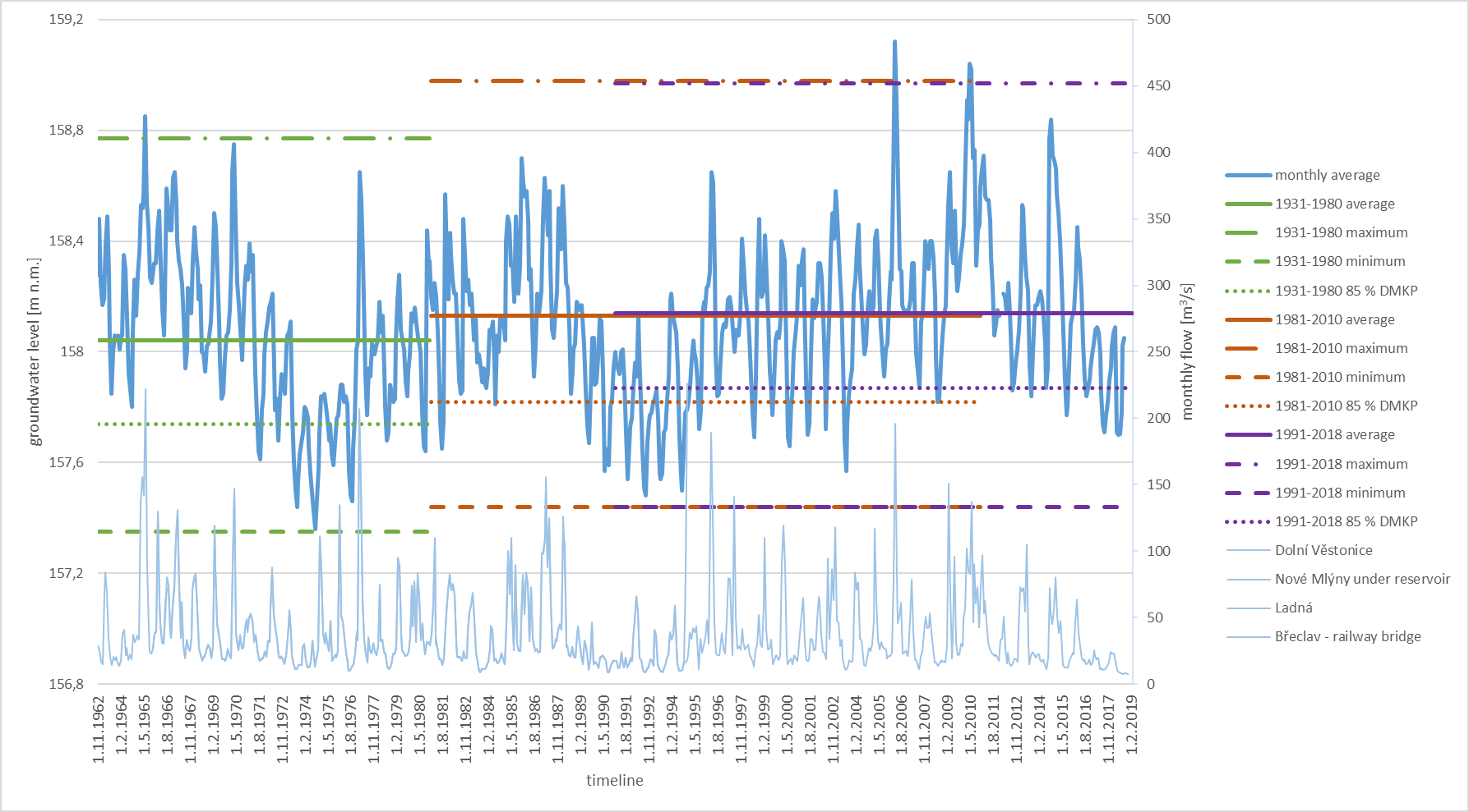
Fig. 10. KB0718 probe assessment
Water management modifications brought about many changes, which had a significant impact on natural and anthropogenic systems in the area of interest. Extensive forest areas, meadows, pools were flooded, watercourse channels were altered, as well as land use. Water management modifications associated with the constructions of the Nové Mlýny dam significantly disrupted “natural” conditions for the development of floodplain geobiocenosis. It leads to a disruption of fluvial processes, as well as the overall hydric regime of the area. Modifications which changed the moisture and fluvial relationships in the area include construction of new river channels, dams, channel shortening etc. Dams are sort of an unnatural barrier. Channel shortening leads to formation of many abandoned meanders. These abandoned river stretches are usually not in hydric contact with the main river flow and therefore cannot be restored, i.e. they gradually degrade. Construction of the
Nové Mlýny reservoir changed the overall hydric regime of the area. Hydrological conditions were disrupted at all types of floodplain biocenoses. Drought also affected floodplain meadows, where there is an obvious decrease in grass-herb associations with dominance of hygrophilous or wetland species. The above mentioned proves countless studies (Buček et al., 2004).
Data from the probe at HP Ladná leads to the following conclusions. Each probe in the profile is unique and its assessment therefore requires taking into account several factors, such as landscape and vegetation conditions near the probe, geological profile, potential effect of other watercourses, not just the main one, which in all these cases is the Dyje River. All probes interact with surface waters, however, what is important is the distance from the watercourse, which affects the dynamics of groundwater levels.
Construction of the Nové Mlýny reservoir led to a decrease in groundwater levels at the KB0706 probe because it is directly dependent on regulations of the Dyje River. In case of other probes there is an obvious decrease in groundwater levels after the construction of the Nové Mlýny dam. During 1990s there is an increase in groundwater levels, which manifested itself in long-term characteristics of the two recent periods. This increase is caused especially by regular floods in the area, because it is an area of riparian forests. These changes directly affected the probes KB0719 and KB0718. The KB0689 probe lies outside the flooded area, however increase can also be observed here and it has less significant fluctuations compared to the other probes. 1990s were quite rich in terms of groundwater thanks to floods groundwater levels could increase and reach their normal values. Since 2010, however, one can see a decreasing trend in groundwater levels, with only seasonal increases.
CONCLUSION
Groundwater level observations at hydropedological profiles are significant especially because of relating it to a profile and a particular watercourse and because of the duration of continuous monitoring. Apart from other uses it can be used for determination of hydraulic relationships between surface water and groundwater. This data can be useful especially for the determination of potential spread of groundwater pollution from surface waters. Knowledge of groundwater regime at a profile (during standard climatological and hydraulic year) allows one to conclude that in long-term, the annual course of groundwater level at all boreholes is roughly the same, with a minimum in October and maximum in April, between which there is a gradual change of the groundwater levels. Groundwater level at a specific borehole is affected by river flow rates, very little by precipitation. Groundwater level does not lie deep below the ground. Deepest it gets is 5 m below the terrain, maximum levels close to a river can reach above the ground. Fluctuation of groundwater level is quite large given the overall thickness. Difference between maximum and minimum level is on average approximately 1 m. Highest values are observed at boreholes close to rivers, where this difference can be up to 2.5 m. Based on long-term time series it is possible to also assess specific periods. The most important period at most boreholes is the 12-month period, which corresponds to seasonal replenishment of groundwater. In case of 70-year long series one can also see statistically significant 30-year periods. Occurrence of these periods is also related to the occurrence of minimum groundwater levels, which occur with approximately 10-year period. In the Dyje basin, groundwater level decreased by approximately 0.5 m after 1972 and fluctuations are less prominent, which is due to the modifications of the Dyje River.
Up to three zones (narrower, water and outer) can be distinguished in terms of the effect of a watercourse (river) on a groundwater in its floodplain. In the narrow belt along the watercourse channel, every significant deviation of water level in the river channel results in a significant change in groundwater level. As the distance from the watercourse increases, this deviation decreases and there is a certain time delay. A groundwater level regime in a floodplain is characterized by alternation between a period when water is received by infiltration of surface water and a period when it is the other way around, i.e. groundwater flows to the watercourse, which occurs when surface water levels are low. In the wider zone the immediate effect of surface water deviations is reduced, only long-term exceptional increases in water levels or their long-term high levels manifest themselves by increase of groundwater levels. In the outer zone the groundwater level is only affected by the river if increased river water levels lead to increase in shallow groundwater levels in the narrower and wide zone, which increases the potential for flow off of groundwater into the outer zone. Result of such increase is an increase in groundwater levels in the outer zone.
Shallow groundwater in floodplain sediments can therefore be donated not just by water coming from precipitation or by water from e.g. valley hillsides, but also by infiltration of surface water from watercourse channels. Its extent depends on the mutual position of surface and groundwater levels, its slope and hydraulic link. This depends on the depth and width of the channel and river bed and river bank permeability, which can be affected by secondary barrier in the form of fine-grain sediments, forming a colmatation barrier. Changes in surface water levels in a watercourse result in slope variability of groundwater levels, as well as the direction of its movement. In general, during high water levels groundwater in a floodplain flows away from the watercourse towards the surrounding area and likewise during low water levels (low flow rates) vice versa. However, apart from that groundwater in permeable sediments of floodplains also moves downwards, i.e. most commonly in the direction of river flow. Shallow groundwater levels therefore fluctuate in accordance with deviations in surface water levels, but always with a certain temporal delay. Amplitude of this fluctuation decreases with increasing distance from the watercourse channel. Predominant effect of a river on shallow groundwater in quaternary fluvial sediments of a floodplain is therefore apparent under the conditions of hydraulic linkage. Contrarily it can be said that a characteristic feature of shallow groundwater of a floodplain is its temporal and spatial dependence on river flow rate regime. River water levels affect fluctuation of groundwater levels and direction of flow of shallow groundwater in a floodplain.
REFERENCES
Buček A., Madera P., Packová P. Hodnocení a predikce vývoje geobiocenóz v PR Věstonická nádrž. Geobiocenologické spisy ; sv. č. 8. 80-7157-781-2 (brož.).
Culek M. Óda na údolní nivy. Veronica. 1992. Vol. 7(3). P. 29-30.
Hornova H. & Černà I. Sledování a vyhodnocení hladin podzemní vody v hydropedologickém profilu Ladná. In: Sborník příspěvků z mezinárodní konference „Hospodaření s vodou v krajině“. Třeboň 13 - 14 June 2019, Třeboň, Czech Republic. 2019. ISBN 978-80-87577-88-2.
Prach K. Údolní niva v kulturní krajině. In: Prach, K., Pithart, D., Francírková, T.: Ekologické funkce a hospodaření v říčních nivách. Botanický ústav AV ČR. Třeboň. 2003. P. 7-14.