LOWLAND RUNOFF SURVEY AND MODELING FOR DECISION SUPPORT IN MANAGEMENT OF THE TRANSBOUNDARY PALIC-LUDAS CATCHMENT AREA
Enikő Anna Tamás¹, István Göttlinger¹, Emese Kutassy¹, György Varga¹
1 National University of Public Service, Faculty of Water Sciences, Baja, Hungary
Corresponding author: Enikő Anna Tamás, NUPS FWS, H-6500 Baja, Bajcsy-Zs.u.14., tamas.eniko.anna@uni-nke.hu
ABSTRACT
Palic and Ludas lakes are located in the northern part of Vojvodina, Serbia near the town of Subotica, just a few kilometers south of the Hungarian border. While Palic lake has a long history as a tourist attraction and a nice recreational setting, Ludas lake and the surrounding steppe plains are habitats of international importance and protected by the Ramsar convention on wetlands. The lakes are connected through the Palic-Ludas canal. Thus Ludas lake is fed partially from Palic lake, but also supplied by the Körös river. The majority of the catchment area of the Körös river is in Hungary, this way the water supply problems related to the lakes are transboundary. The lake system is also drained by the Körös, which finally enters the Tisza river.
Water quality problems and water quantity decrease are both identified and are escalating threatening factors at the lake system in the past decades. Several studies have been carried out in the past about the possible reasons and solutions. The authors have studied the previously published results and have been participating in a cross-border cooperation project funded by the IPA, in frame of which a comprehensive survey and measurement program has been carried out in order to develop, among others, a rainfall-runoff model of the catchment for the investigation of water supply scenarios of the lake system in order to substantiate a monitoring network and program for the sustainable management of the lakes.
In our article we introduce the area, the problem, the field surveying and measurement methodologies and results, the modeling process and the model itself, concluding transboundary responsibility for water supply to the lake system, with a possible complex connection to one of Hungary’s major water management issues.
INTRODUCTION
The management of water resources across boundaries, whether sub-national or international, is one of the most difficult challenges facing water managers today. The upstream exploitation or diversion of groundwater or rivers can have devastating consequences for those living downstream, and transboundary rivers can provide a source of conflict between nations or states, particularly where water resources are scarce. Similarly, water based-pollution can spread across borders and create disputes and a need for sound governance (Earle, 2013).
In our article we are discussing a case of a transboundary small catchment in which the majority of the problems can largely be attributed to the water management issues in the upstream country, Hungary.
METHODS AND DATA (STUDY AREA)
Ludas Lake is Pannonia Plain Lake located 4km from Palic town. It is a shallow, natural aeolian lake created million years ago. Ludas Lake Special Nature Reserve was included in the list of Wetlands of International Importance by the Ramsar Convention in 1977. In 1989, the lake and its surroundings were designated as an Important Bird Area. The surface of protected zone covers 2.002 ha. Ludas Lake is hydraulically connected to the Palic Lake by Palic-Ludas Channel, and it is the recipient Palic Lake water (Fig. 1) (Radic et al., 2013). Palic Lake is also the recipient of the outflow from the Subotica WWTP (Horvat et al., 2019). Thus, Ludas lake is fed partially from Palic lake, but also supplied by the Körös river. The majority of the catchment area of the Körös river is in Hungary, this way the water supply problems related to the lakes are transboundary. The lake system is also drained by the Körös, which finally enters the Tisza river.
The transboundary Palic-Ludas catchment is home to multiple aquatic habitats. The state of these habitats is governed by the water regime and water quality of the Palic and Ludas lakes. Therefore, the development of a sustainable water resources management policy on this catchment is of great importance.
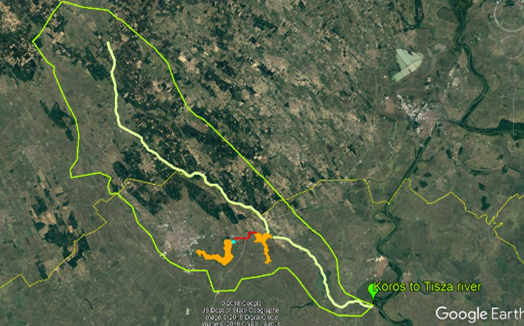
Fig. 1. Overview map of the transboundary catchment area (yellow: Körös-ér channel,
red: Palic-Ludas channel, orange: Palic and Ludas lakes)
In frame of a recent Hungarian-Serbian IPA CBC project HUSRB/1602/12/0014 „Sustainable wetland management of the transboundary Palic-Ludas catchment area” / „A határon átnyúló PalicsLudas vízgyűjtő terület fenntartható vízgazdálkodása” (SWeM-PaL) we have collected historical data and surveyed the missing ones in order to be able to set up a model and help suggest possible improvement solutions as regards to the water quantity and quality of the two lakes, which have deteriorated significantly in the past decades.
The on-site measurements were done with standard surveying equipment (RTK GPS, SonarMite M8 ultrasonic depth meter, standard leveler and static GPS measurements).
The cross-sections and the longitudinal profile of the Hungarian part of the Körös river, as well as the delineation of the Hungarian part of the catchment area were provided by the Lower Tisza district Water Authority (hq: Szeged).
In order to get to a better understanding of the water regime of the area, we also executed discharge measurements, because there is only one permanent gauging station in the whole system, and it is on the Körös river in the Hungarian part.
The equipment used in discharge measurements were an OTT C2 type propeller current meter and an ADCP RiverPro/RioPro.
We used all the obtained data in our modeling tasks described hereafter, for which we applied commercial software (AutoDESK/AutoCAD, ArcGIS and HEC-RAS 1D and 2D by the US Army Corps of Engineers).
RESULTS AND DISCUSSION
During the modeling, the 1D hydrodynamic model of the Körös-ér inlet channel, the 2D hydrodynamic model of Lake-Ludas were established using geodetic measurements, and the direct catchment area of Körös-ér basin was determined based on the available satellite digital terrain models.
One-dimensional hydrodynamic model
As a first step, the runoff model of the Körös-ér and its surroundings was prepared. From this, it is possible to determine the possible amount of water that would load the canal if the field assembly and run-off did not suffer any obstructions. Subsequently, a one-dimensional hydrodynamic model of the Hungary-Serbia section of the Körös-ér was created. During modeling, roughness factors corresponding to the field conditions and the riverbed conditions experienced during the survey were taken into account. According to the data of the water level and discharge sensor station in the Hungarian section of the Körös-ér, the highest discharge in the last 5 years was 1.1 m3.
The primary purpose of the 1D model is to determine the drainage capacity of the canal, and to investigate the water levels associated with 1.1 m3 discharge in critical cross sections.
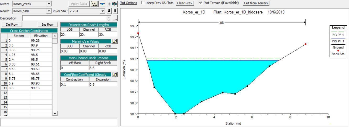
Fig. 2. Körös-ér cross-section - [2+254 rkm]
Based on the results of the model run (Fig. 2), the discharge capacity of the sections is adequate. The second purpose of the run is to determine the maximum discharge capacity of the canal.
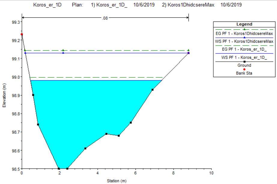
Fig. 3. Körös-ér cross-section - maximum discharge capacity - [2+254 rkm]
Based on the results, the cross sections are capable of draining an additional 500 l/s of water, totaling 1.6 m3/s – (Fig. 3). Difference in free water surface between observed discharge and maximum possible discharge is 14 cm.
Two-dimensional hydrodynamic model - Lake-Ludas
During the two-dimensional modeling of Lake Ludas, the riverbed survey data made in the summer of 2018 and 2019 were used. In the course of the study, we analyzed the effects of the discharges of the Körös-ér and the inlet of Lake-Palic on the flow conditions of Lake Ludas. The geometry underlying the model was processed in Civil 3D. The digital terrain model built from the data was exported in TIF format with a grid size of 1x1 m.
During the model construction we used the 0.631 m3/s water discharge of the Lake-Palic connection canal and the 1.1 m3/s water discharge of Körös-ér as the upper boundary condition. For lower boundary condition we used the Lake-Ludas threshold level.
Geometry has been taken into account when considering the condition of the lake at the time of bathymetry, especially the reed areas influencing the roughness coefficients. The SENTINEL-2 satellite photo taken at the time of the bathymetry was used to determine the roughness coefficients accurately (Fig. 4).
The satellite photo has been used to separate the open water surface and the reed surface using ArcGIS-ArcMAP. In the course of the operation, we used image classification, whereby a training sample was used to create pattern recognition that distinguishes the open water surface and the reedcovered areas with high accuracy compared to the image resolution.
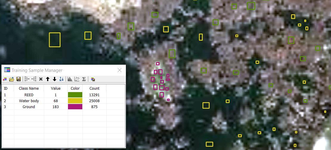
Fig. 4. Image classification: preparing the training sample - Lake-Ludas
The result of the GIS analysis is a file with the SHP extension that represents the watercovered and reed areas as polygons. Importing this file into HEC-RAS allows us to set the Manning roughness factor for different polygons.
After setting the bed geometry and the Manning roughness factors, a two-dimensional hydrodynamic modeling of the lake requires the construction of a computational grid. The size of the grid was determined at 10x10 meters, and a resolution of 2.5x2.5 meters was used at the connection points serving as the boundary condition.
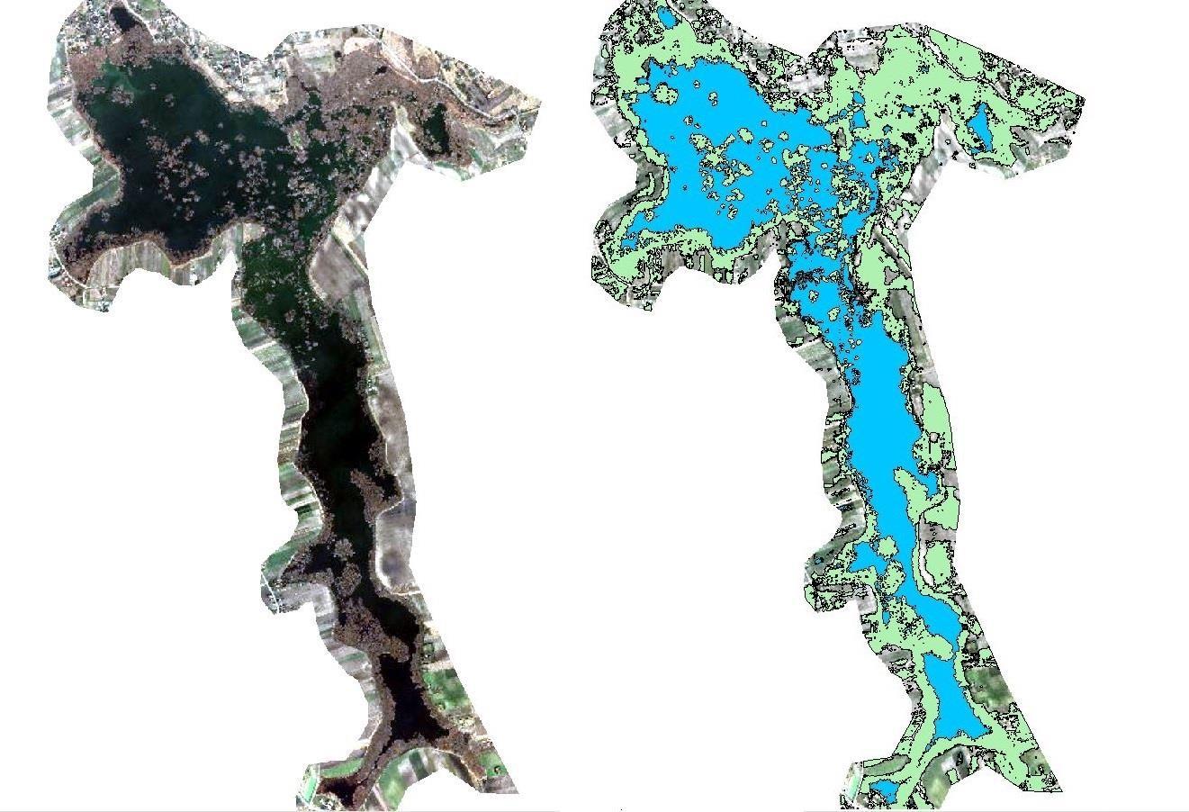
Fig. 5. Maximum-likelihood classification: Open water surface (blue); Reed coverage (green)
First stage - modeling of initial state - investigation of flow conditions
For the analysis of the original conditions we used the measured water discharge of the Palić connecting channel and the 1.1 m3/s maximum discharge observed in the Körös-ér. The velocity distribution in the two-dimensional flow area evolve according to experience (Fig. 6).
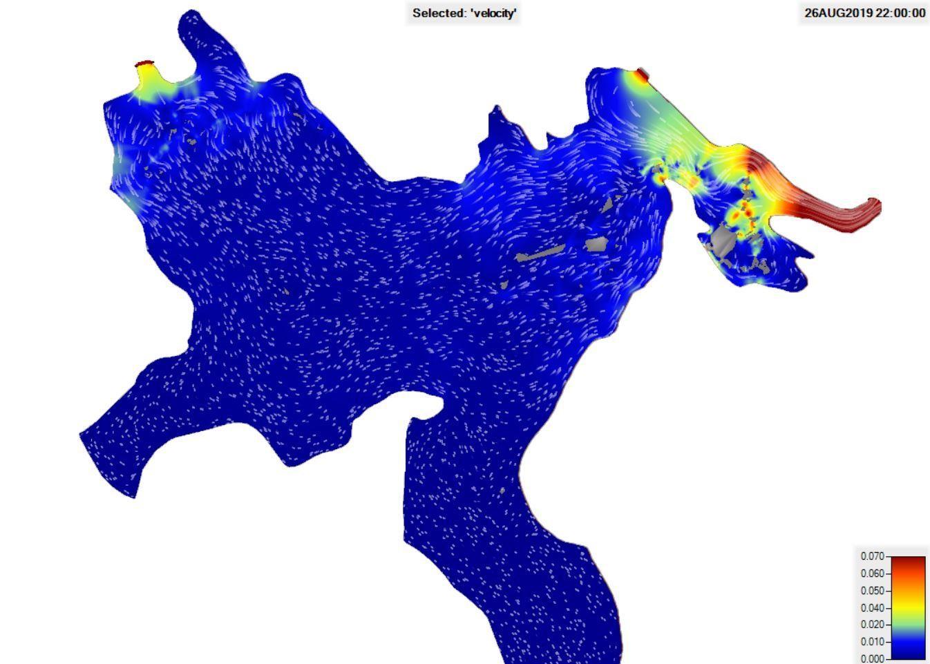
Fig. 6. Velocity-distribution and flow directions - Lake-Ludas
Flow rates are low and the volume of fluid that is heavily moved is small compared to the lake's extent. The maximum water velocity at the connection and discharge points is 0.11 m/s.
Second Stage – modeling of changes in upper boundary conditions
Using original bed geometry, the upper boundary conditions of the hydrodynamic model were modified by increasing the discharge from the Palić-connection channel to 2.2 m3/s. Provided 0 discharge to the connecting Körös-ér. The aim of the analysis was to improve the flow conditions of Lake Ludas. The increased drainage of the interconnecting channel causes a rearrangement of the flow directions (Fig. 7).
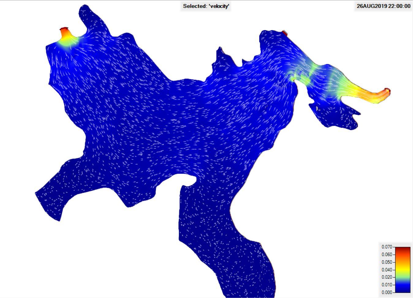
Fig. 7. Velocity-distribution and flow directions in second stage - Lake-Ludas
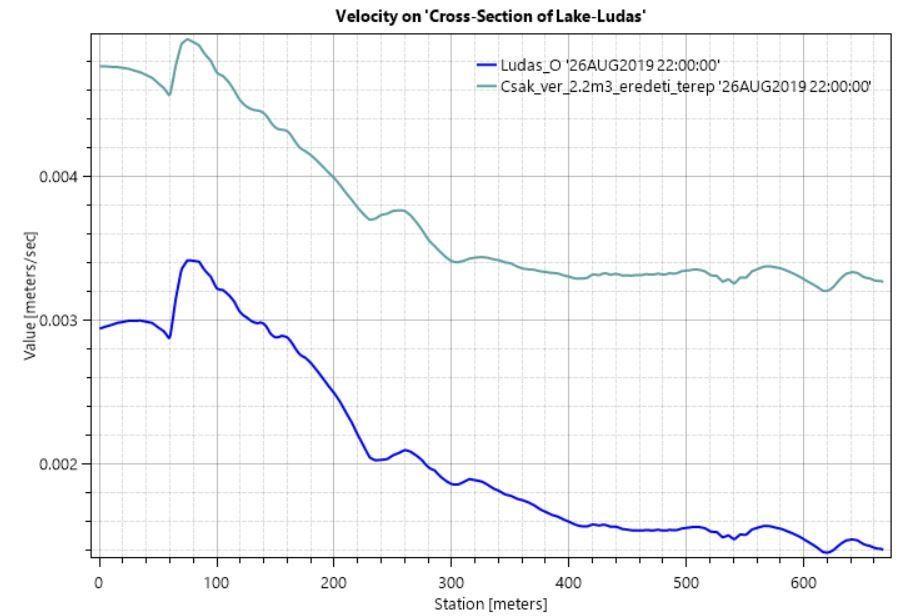
Fig. 8. Velocity: Cross-Section of Lake-Ludas
The results show that the lake is flushed over a larger area. Speed conditions in the middle section of the lake increase by an average of 5 m/h.
Third stage - modeling of modified geometry of lake bed
In the third phase, the aim was to improve the flow conditions of Lake Ludas through artificial interventions. The intervention is the dredging of the lakebed, which connects the Palić connecting channel to the outlet of Lake Ludas. In order to prevent the amount of water delivered by the Körösér to the Ludas Lake from flowing directly into the outflow section, an additional connecting dredging was planned, which will be connected to the Palić ditch in the middle of the lake (Fig. 9).
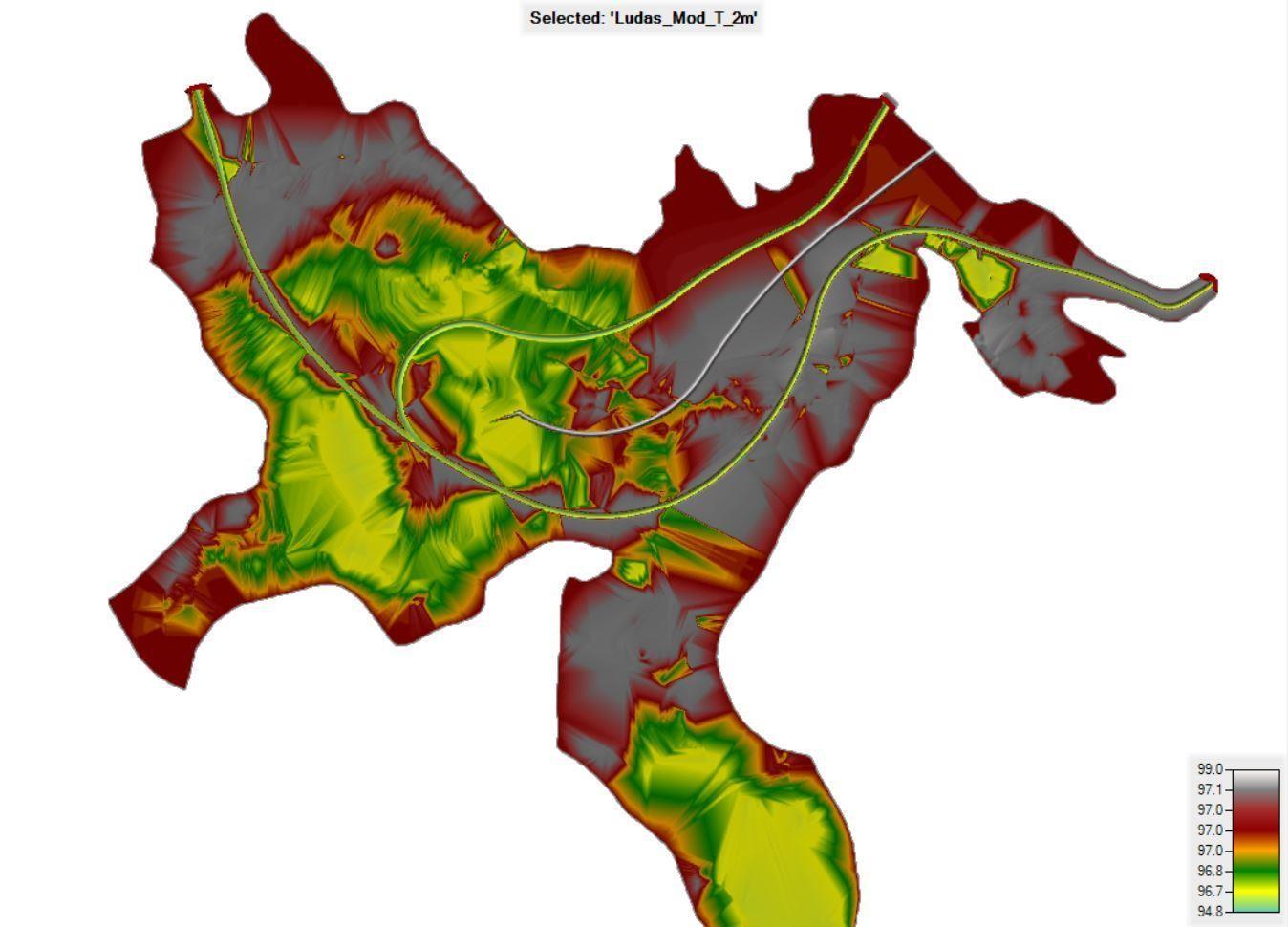
Fig. 9. Original and modified lakebed
The excavation section is 2 meters deep and has a slope of 1:2. In addition, a reed wall was added to change the direction of flow towards the center of the lake.
The purpose of the modified bed geometry was to increase the flow area of the lake, which is heavily moved. Changes in model geometry favorably affect the flow pattern. The intensively displaced water surface increases significantly (Fig. 10-11).
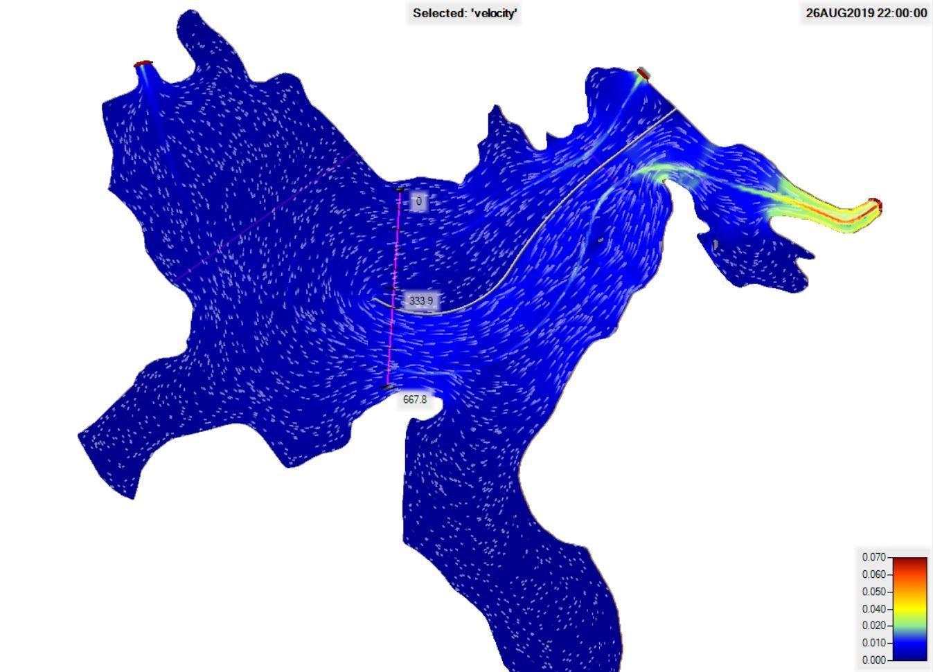
Fig. 10. Velocity-distribution and flow directions - modified geometry of Lake-Ludas
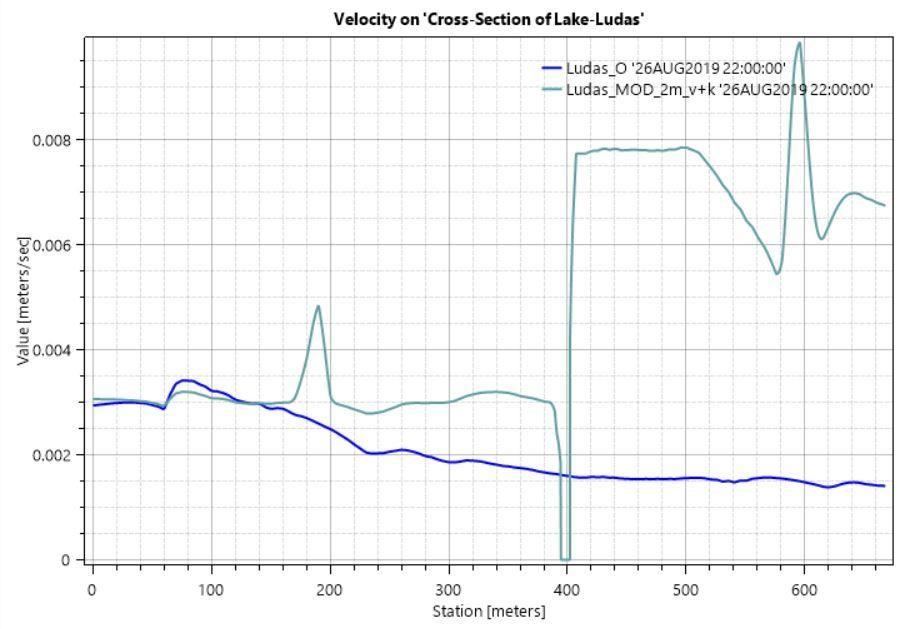
Fig. 11. Velocity-distribution and flow directions 2 - modified geometry of Lake-Ludas
Figure 11 shows an increase in water velocities. Blue for original condition, green for dredging. The figure shows 3 peaks from left to right: dredging - reed wall – dredging, the beneficial effect on velocity distribution.
CONCLUSIONS
With our work, we give an example for the support of the decision making processes by hydrodynamic modeling.
In our case, a water system with a very complex system of problems can only be investigated and managed with international co-operation.
In the current practice, Hungarian water authority only manages the Hungarian part of the catchment and consequently has no maps, data, information or measurements from the Serbian part and vice versa. Without solving monitoring and data management issues on the transboundary level, a project was needed in order to collect all information, do measurements and try to find solutions for the different water related problems of the Palic and Ludas lakes.
In our conclusions, we can say that one of the biggest problems encountered is the extremely low, often zero flow rate of the Körös, which shall supply the Ludas lake with freshwater. Unfortunately, the phenomenon is clearly connected to the decreasing of the surface and groundwater levels in the central Hungarian plain, which has now been observed for more than 20 years. Solution to the water supply problem can only be elaborated in harmony with other Hungarian regional projects.
However, with our theoretical suggestions for dredging, a considerable improvement could be achieved locally in Serbian territory by removing a part of the sedimented nutrient-rich silt layer from the lake bed and at the same time, improving water circulation. These interventions, together with the already planned improvements in wastewater collection network and treatment in Palic, would help the unique biodiversity of Ludas Lake and the tourist attractions of Palic lake to remain.
REFERENCES
Earle, A. Transboundary Water Management. Principles and Practice. Routledge. 2013. 280 p.
Horvat, M.; Horvat, Z.; Koch, D.; Majer, F. Preliminary analysis of the Palic-Ludas catchment, Hadmérnök, XIV. 2019. Vol 2. P. 202-212.
Radic, D., Gujanicic, V., Petricevic, J., Raicevic, V., Lalevic, B., Rudic, Z., Bozic, M. Macrophytes as remediation technology in improving Ludas lake sediment, Fresenius Environmental Bulletin. 2013. Vol. 22. No 6. P. 1787 - 1791.