ESTIMATION OF MINIMUM AVERAGE MONTHLY RIVER DISCHARGE: YANTRA RIVER, NORTH BULGARIA
Elena Kirilova Bojilova
National Institute of Meteorology and Hydrology
Corresponding author: E. Bojilova, National Institute of Meteorology and Hydrology, Bulgaria, 1784 Sofia,
Tzarigradsko chausses Avenue 66, Elena.kirilova.bojilova@gmail.com
ABSTRACT
Yantra river basin situated in North Bulgaria, is a part of Danube river basin directorate. This investigation is performed in the framework of the project with Bulgarian Ministry of Environment and Water. From the Ministry the points for each effluent or water abstraction facility are provided. For all points it was requested to evaluate 95% probability of occurrence for minimum monthly average river discharge. The provided from the project cross section (points) are along the main river body and also on the main river tributaries: Vidima, Rositza, Belitza and Drianovska rivers.
For the current study data from thirteen hydrological gauging stations in the drainage basin of Yantra river are used. Time series for the 1981-2014 study period are executed. Seven homogeneous regions were determined. Map with homogeneous regions for the Yantra river basin is elaborated and presented. Results are discussed.
YANTRA RIVER BASIN
Yantra river basin belongs to Danube river basin directorate, North Bulgaria. Dimitrov and Yordanova (Dimitrov et al., 2017) worked on trends assessment of meteorological factors, river flow and droughts in Nort-western Bulgaria. Yordanova A. et al., (Yordanova A. et al., 2017) used stoshastic modelling in water resources management. Orehova et al. (Orehova T., 2012) evaluated the potential groundwater recharge of the Ogosta river basin. Yordanova V. et al., (Yordanova V. et al., 2017) applied TOPKAPI model to Ogosta river in Nort Bulgaria. Vasileva et al. (Vasileva Т. et al., 2017) investigated groundwater contribution to the river flow of the Osam river. Furthermore, Ninov and Karagiozova (Ninov et al., 2014; Karagiozova et al., 2017) determined surface water resources in Bulgaria in presence or absence of monitoring stations. In 2012 Hristova (Hristova, 2012) made an overview of river runoff of Bulgaria. Recently, Hristova and Seymenov (Hristova et al., 2019) worked on annual flow dynamics in basins with different sizes located in North Bulgaria. The watershed of river Yantra is situated between Osam river basin from West direction, Rusenski Lom and Kamchia rivers from East, form North the border is Danube river. To the south Balkan mountain is a water divide with the rivers Maritsa and Tundja. Within these limits, the catchment area is about 7 862 km2. The Yantra River originates from Mount Hadji Dimitar, approximately 1 340 m above mean sea level. The river is around 285 km long and at approximately 18 m altitude flows into the Danube River near Krivina village. Up to Veliko Turnovo town the river flows in north-east direction. After Veliko Turnovo the river turn in east direction making curve and since that is flowing in north direction.
The Yantra River has thirty tributaries over 10 km in length. More significant tributaries are: the Rositsa River, 164 km long and catchment area of 2265 km2; Lefeja River - 92 km in length and catchment area 2424 km2; Djulyunitsa River - 85 km in length and area of 892 km2 etc. The river density in the watershed is varied. For the main river the density is 0.7 km/km2. For the tributaries the density is in the range of 0.3 km/km2 (Eliiska river) to 1.5 km/km2 (Ostrazka river). The average altitude for the entire catchment area is 470 m and the average slope varies from 10.6 ‰ (Stara reka River) to 48 ‰ (for the Plachkovska River). River Yantra has an average slope of about 34 ‰ in its upper stream, while at the mouth it reaches 0.25 ‰, where it is also characterized by a high coefficient of curvature village.
The relief in the upper part of the catchment is mountainous and abounds in high mountain ridges and peaks. The middle part is characterized by many hilly heights. The lower stream, which crosses the Danube Plain, is characterized by smooth rounded hills, which cross the low terraces near the Danube.
INFORMATION PROVIDED FROM THE MINISTRY
The Bulgarian Ministry of Environment and Water was provided the points for each effluent or water abstraction facility. For all points it was requested to evaluate 95% probability of occurrence for minimum monthly average river discharge. The requested for the project cross section (points) are along the main river body and also on the main river tributaries. For the drainage basin of Yantra river the points are 195. The majority of the points are along the main river body and also in the drainage basins of Vidima, Rositza, Belitza and Drianovska rivers (Fig. 1).
ESTIMATION OF THE MINIMUM MONTHLY AVERAGE RIVER DISCHARGE WITH 95% PROBABILITY OF OCCURRENCE AT THE POINT OF EACH EFFLUENT OR WATER ABSTRACTION FACILITY IN THE YANTRA RIVER BASIN
HYDROLOGICAL INFORMATION
In the catchment of Yantra river, the monitoring network of National Institute of Meteorology and Hydrology (NIMH) consist of 13 hydrological gauge stations. Three of them are situated on the main body of Yantra river (at Gabrovo city (23650); Veliko Tarnovo town (23700) and Karantsi village - 23850) and others are on its tributaries. In terms of area, the stations cover the whole catchment area, with their density in the upper and middle part of the catchment being greater than in the lower flat part.
The author performed extended studies concerning integrated river basin modelling of Yantra river (Bojilova, 2006; Bojilova, 2011). So far, the models with distributed (HYDROBEAM) and semi-distributed parameters (HEC-HMS) were applied. River basin modelling under future climate conditions was performed too (Bojilova, 2017).
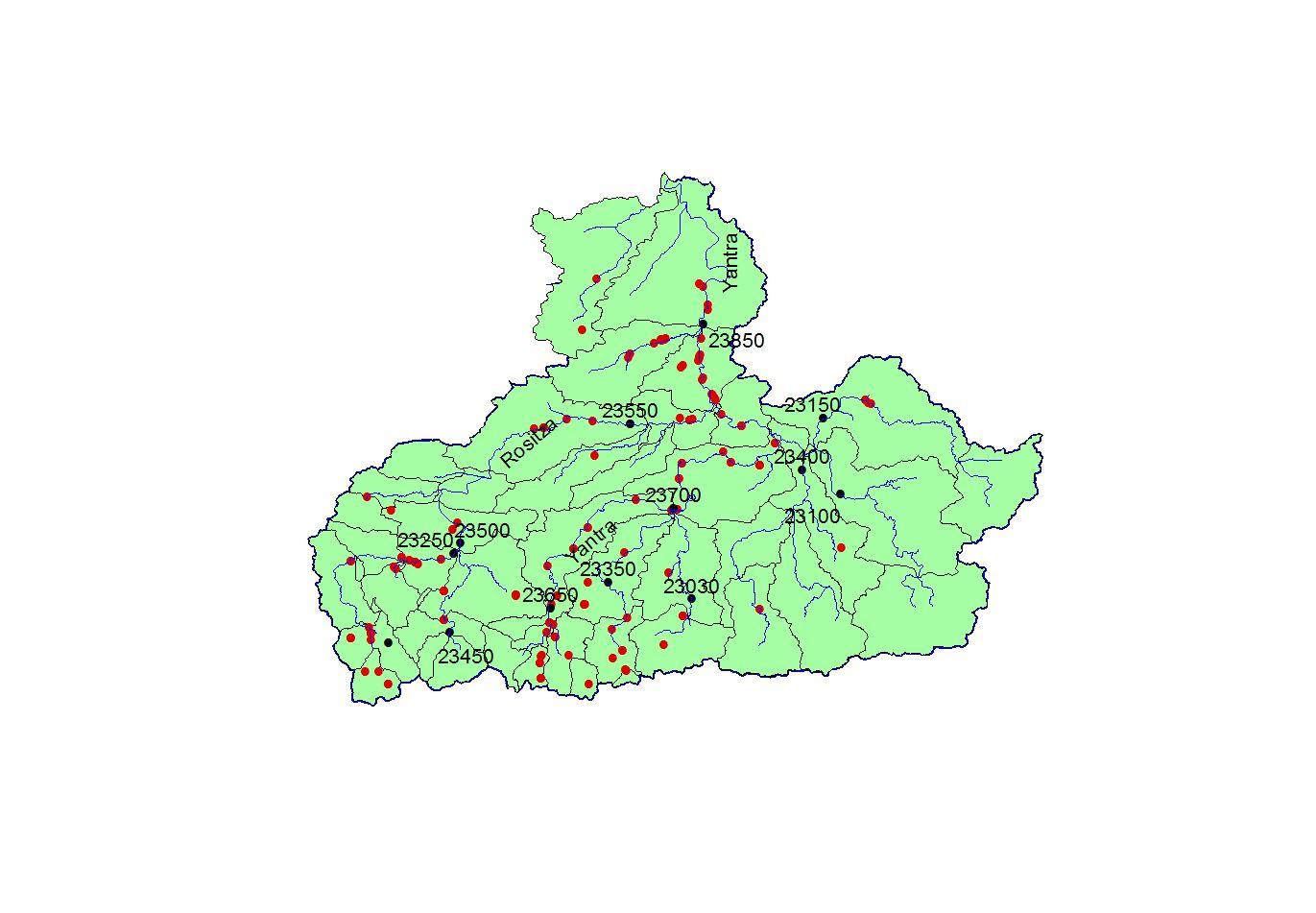
Fig. 1. Points for investigation (in red) and hydrological gauging stations (in black)
For the purposes of the current study, time series with minimum average monthly river discharges from all stations are used. For the differentiation of the individual regions a comparative expert assessment of the conditions for formation of the runoff in the entire catchment was made. The upper stations are mountain with a large slope and a small catchment area. Gradually the slope decreases, but the area does not grow so fast. Midrange stations have a smaller slope but have a larger area.
METHODOLOGY
A 1981-2014 observation period was selected. For the purposes of the study, time series with minimum monthly water discharge for all hydrological stations were formed. The used data range consists of 34 elements. The empirical distribution values of the minimum monthly runoff with 95% probability of occurrence are determined.
The method of hydrological regionalization has been used. The method is statistical by applying regression analysis. With its help, regional regression equations are created. Regression establishes a statistical relationship between the runoff (minimum monthly average water discharges with 95% probability of occurrence) and selected water catchment characteristics (the catchment area).
The methodology for hydrological regionalization does not allow determination of runoff in isolated water bodies with extremely small area (up to 10 km2), since it is possible that the determined water quantity is not within the tolerable error for the method. The method of analogy and method of transfer of the drainage module from the station are also used. After a detailed analysis of the Yantra river basin, four homogeneous regions using the regional correlation method are obtained. Three regions were determined using the transfer method of the drainage module from the hydrological station to the point of any effluent or water abstraction facility.
Defined homogeneous regions
Region 1 – Dryanovska-Belitza-Djulyunisa rivers
For this region the station at village Vagletzi for Belitza river (23030), Dryanovska River – at Tsareva Livada (23350) and Djulyunitsa river (station 23400) are used.
Fig. 2. Homogeneous regions for Yantra river basin
Region 2 – Vidima river
The following gauging stations are applied: Ostrezka river at Aprilovzi village (23200), Vidima river at Sevlievo city (23250) and Vidima river at village Vidima (23180).
Region 3 – Yantra river
The stations along the main river body are used: Yantra river at Gabrovo city (23650), Yantra River – Veliko Tarnovo town, in the district of Cholakovtsi (23700) and Yantra river at village Karantsi (23850). This is region on the main river body.
Region 4 - Rositsa River after Sevlievo
The used stations are: Vidima river at Sevlievo (23250), Rositsa River at Sevlievo (23500) and Rositsa River near the village of Vodoley (23550).
Region 5 - Rositsa River up to Sevlievo
This region covers upper part of Rositsa river to the station at Sevlievo city. One more station is utilized Rositza river at village Valevtzi (23450). The method of transfer of drainage module is used.
Region 6 – Lefedja and Golyama Reka rivers
The used stations are: Golyama Reka river near Strazhitsa village (23150) and Lefedja river (Stara Reka) at Slivovitsa (23100). The method of transfer of drainage module is used.
Region 7 - Eleeska river
We have been used for this region closed hydrological station Eleeska river at village Polski Trambej (23570). For this area we also applied the method of transfer of drainage module.
After determination of the homogeneous regions 95% probability of occurrence for minimum monthly average river discharge for the points for each effluent or water abstraction facility were evaluated. Seven regions were determined: four homogeneous regions using the regional correlation method and three regions using the transfer method of the drainage module from the hydrological station to the point of any effluent or water abstraction facility. Data for 195 points were calculated and presented to the Bulgarian Ministry. For visualization, the map with the homogeneous regions in Yantra river watershed was prepared (see Fig. 3).
Fig. 3. Defined regions in Yantra river basin with 95% probability of occurrence
for minimum average monthly river runoff
RESULTS AND DISCUTIONS
The Bulgarian Ministry of Environment and Water was provided the points for each effluent or water abstraction facility. For all points it was requested to evaluate 95% probability of occurrence for minimum monthly average river discharge.
The method of hydrological regionalization has been used. With its help, regional regression equations were created. Regression establishes a statistical relationship between the minimum monthly average water discharges with 95% probability of occurrence and the size of catchment area. The method of analogy and method of transfer of the drainage module from the station has been also used.
After a detailed analysis of the Yantra river basin, four homogeneous regions using the regional correlation method were obtained. Three regions were determined using the transfer method of the drainage module from the hydrological station to the point of any effluent or water abstraction facility. Map with homogeneous regions for the Yantra river basin was elaborated.
REFERENCES
Bojilova E. Integrated river basin modelling, Bulgarian case study. HydroEco2006, Proceeding of Multidisciplinary conference, Karlovy Vary, Czech Republic, ISBN 80-903635-1-2, 2006. P. 187-190. doi:
10.13140/2.1.1587.8404
Bojilova E. Flow modelling of the Yantra river, Bulgaria. XXV conference of the Danubian countries, June 2011, abs. P. 155, full text on USB, Editors: G. Balin and M. Domokosh, ISBN 978-963-511-151-0, 2011. doi: 10.13140/RG.2.1.1303.3043
Bojilova E. River basin modelling under future climate conditions. Impact approach. Part I, E-book with full paper from XXVII Conference of The Danubian Countries, 26-28 September 2017, Golden Sands, Bulgaria,
ISBN 978-654-90537-2-2, P. 558-569. www.danubeconference2017.org
Dimitrov Y., Yordanova A. Trends assessment of meteorological factors, river flow and droughts in Northwestern Bulgaria. E-book with full paper from XXVII Conference of The Danubian Countries “On Hydrological Forecasting and Hydrological Bases of Water Management”, 26-28 September 2017, Golden Sands, Bulgaria, ISBN 978-654-90537-2-2, 2017. www.danubeconference2017.org
Karagiozova Tz., Ninov P. Determination of water resources in the national park Rila in the absence of a monitoring network. E-book with full paper from XXVII Conference of The Danubian Countries “On Hydrological Forecasting and Hydrological Bases of Water Management”, 26-28 September 2017, Golden Sands, Bulgaria, www.danubeconference2017.org, ISBN 978-654-90537-2-2, 2017.
Ninov Pl., Karagiozova Tz. Technological Approach to determine the water resources of river water bodies - using hydrological monitoring network. Hydrological International Scientific Conference „Adaptation to climate change, from source to river basin”, Bucharest, 2014.
Orehova T., Zektser I., Benderev A., Karimova O. Evaluation of the potential groundwater recharge: The example of the Ogosta river basin. Comptes Rendus de L'Academie Bulgare des Sciences, 65, 10, 2012. 1387-1395, ISSN 1310-1331
Нели Христова. Речни води в България. 978-954-723-000-4, Издателска къща „Тип-топ прес“, 2012. 500 p. [Neli Hristova. River flow in Bulgaria, Tip-top press, 2012. 500 p. in Bulgarian]
Hristova N., Seymenov K. Annual flow dynamics in large and small drainage basins in Northern Bulgaria during the last two decades. SocioBrains. ISSN 2367-5721, journal homepage: www.sociobrains.com, February 2019. Issue 54, P. 123-131.
Vasileva Т., Orehova T., Kroumova K. Groundwater contribution to the river flow for the upper course of the Osam River based on two baseflow separation methods. Geologica Balcanica, 2017. 46, 2, 73-82, ISSN 0324-0894
Yordanova A., Niagolov I., Ilcheva I. Aspects of stochastic modeling in water resource management. E-book with full paper from XXVII Conference of The Danubian Countries “On Hydrological Forecasting and Hydrological Bases of Water Management”, 26-28 September 2017, Golden Sands, Bulgaria, ISBN 978-654-90537-2-2, 2017. www.danubeconference2017.org
Yordanova V., Balabanova Sn., Stoyanova V. Application of the TOPKAPI model on the Ogosta river basin. E-book with full paper from XXVII Conference of The Danubian Countries “On Hydrological Forecasting and Hydrological Bases of Water Management”, 26-28 September 2017, Golden Sands, Bulgaria, ISBN 978-654-90537-22, 2017. www.danubeconference2017.org